Lexington geodata
Lexington (Virginia) is a seat of a second-order administrative division; located in United States in America/New_York (GMT-4) time zone. With population of 7,262 people, there are 5672 cities with bigger population in this country. Compared to other cities in United States, 62.7% of cities are located further ↑North; 75% of cities are located further ←West and 76.3% of cities have lower elevation than Lexington. Note1


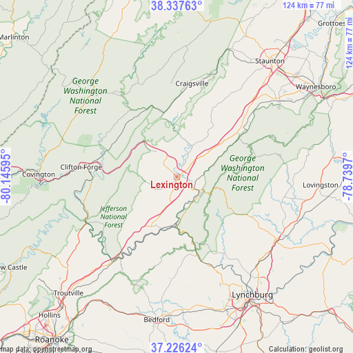
Lexington GPS coordinates[2]
37° 47' 2.472" North, 79° 26' 34.152" West
| Map corner | latitude | longitude |
|---|---|---|
| Upper-left | 38.33763°, | -80.14595° |
| Center: | 37.78402°, | -79.44282° |
| Lower-right: | 37.22624°, | -78.7397° |
| Map W x H: | 123.6×123.6 km | = 76.8×76.8mi |
| max Lat: | 71.29058° ⇑62.7% North |
| Lexington: | 37.78402° |
| min Lat: | ⇓37.3% South 19.06759° |
| min Long | Lexington | max Long |
| -171.73463° | -79.44282° | -66.98998° |
| W 75%⇐ | ⇒25% E |
Elevation
Elevation of Lexington is 322 m = 1056 ft, and this is 27.2 m = 89 ft above average elevation for this country.
| Max E: |
3189 m = 10463 ft | 23.7% |
| Lexington | 322 m 1056 ft | |
| Avg. | 294.8 m = 967 ft | |
Min E: |
-60 m = -197 ft | 76.3% |
See also: United States elevation on elevation.city.
Geographical zone
Lexington is located in North temperate zone (between Tropic of Cancer and the Arctic Circle). Distance of this Northern Tropic circle is 1595.3 km =991.3 mi to South.| Distance of | km | miles | from Lexington |
|---|---|---|---|
| North Pole | 5805.9 | 3607.6 | to North |
| Arctic Circle | 3200 | 1988.4 | to North |
| Tropic Cancer | 1595.3 | 991.3 | to South |
| Equator | 4201.2 | 2610.5 | to South |


Nearby cities:
15 places around Lexington: (largest is in red/bold)
• Amherst
40.9 km =25.4 mi,  122°
122°
• Buchanan
35.3 km =21.9 mi,  216°
216°
• Buena Vista
9.6 km =6 mi,  125°
125°
• Clifton Forge
33.7 km =20.9 mi,  276°
276°
• Craigsville
33.2 km =20.6 mi,  9°
9°
• East Lexington
1.8 km =1.1 mi,  57°
57°
• Fairlawn
47.4 km =29.5 mi,  268°
268°
• Glasgow
16.7 km =10.4 mi,  182°
182°
• Greenville
35.1 km =21.8 mi,  45°
45°
• Hot Springs
41.7 km =25.9 mi,  305°
305°
• Madison Heights
48.3 km =30 mi,  144°
144°
• Selma
35.7 km =22.2 mi, 274°
• Sherando
48.2 km =30 mi, 62°
• Stuarts Draft
45.1 km =28 mi, 52°
• Warm Springs
42.2 km =26.2 mi, 313°
Sources, notices
• [Note1] Compared only with cities in United States existing in our database
• [Src1] Map data: © OpenStreetMap contributors (CC-BY-SA)
• [Src2] Other city data from geonames.org with taken over terms of usage.
• [Src3] Geographical zone / Annual Mean Temperature by Robert A. Rohde @ Wikipedia
