Amherst geodata
Amherst (Virginia) is a seat of a second-order administrative division; located in United States in America/New_York (GMT-4) time zone. With population of 2,210 people, there are 11312 cities with bigger population in this country. Compared to other cities in United States, 63.7% of cities are located further ↑North; 75.6% of cities are located further ←West and 57.7% of cities have lower elevation than Amherst. Note1


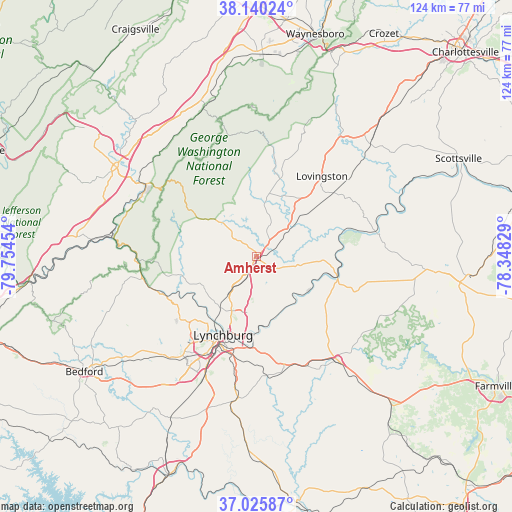
Amherst GPS coordinates[2]
37° 35' 6.504" North, 79° 3' 5.076" West
| Map corner | latitude | longitude |
|---|---|---|
| Upper-left | 38.14024°, | -79.75454° |
| Center: | 37.58514°, | -79.05141° |
| Lower-right: | 37.02587°, | -78.34829° |
| Map W x H: | 123.9×123.9 km | = 77×77mi |
| max Lat: | 71.29058° ⇑63.7% North |
| Amherst: | 37.58514° |
| min Lat: | ⇓36.3% South 19.06759° |
| min Long | Amherst | max Long |
| -171.73463° | -79.05141° | -66.98998° |
| W 75.6%⇐ | ⇒24.4% E |
Elevation
Elevation of Amherst is 229 m = 751 ft, and this is 65.8 m = 216 ft below average elevation for this country.
| Max E: |
3189 m = 10463 ft | 42.3% |
| Avg. | 294.8 m = 967 ft | |
| Amherst | 229 m = 751 ft | |
Min E: |
-60 m = -197 ft | 57.7% |
See also: United States elevation on elevation.city.
Geographical zone
Amherst is located in North temperate zone (between Tropic of Cancer and the Arctic Circle). Distance of this Northern Tropic circle is 1573.2 km =977.5 mi to South.| Distance of | km | miles | from Amherst |
|---|---|---|---|
| North Pole | 5828 | 3621.4 | to North |
| Arctic Circle | 3222.1 | 2002.1 | to North |
| Tropic Cancer | 1573.2 | 977.5 | to South |
| Equator | 4179.1 | 2596.8 | to South |


Nearby cities:
15 places around Amherst: (largest is in red/bold)
• Appomattox
32.3 km =20.1 mi,  141°
141°
• Arrington
17.2 km =10.7 mi,  50°
50°
• Buena Vista
31.4 km =19.5 mi,  301°
301°
• Concord
27.8 km =17.3 mi,  165°
165°
• East Lexington
40.2 km =25 mi,  305°
305°
• Forest
32.4 km =20.1 mi,  220°
220°
• Glasgow
35.6 km =22.1 mi,  278°
278°
• Lovingston
25.1 km =15.6 mi,  39°
39°
• Lynchburg
20.7 km =12.9 mi,  202°
202°
• Madison Heights
18.3 km =11.4 mi, 200°
• Nellysford
37.4 km =23.2 mi,  24°
24°
• Rustburg
34.6 km =21.5 mi,  187°
187°
• Shipman
24.2 km =15 mi, 50°
• Timberlake
34.6 km =21.5 mi,  211°
211°
• West Lynchburg
23.1 km =14.4 mi, 208°
Sources, notices
• [Note1] Compared only with cities in United States existing in our database
• [Src1] Map data: © OpenStreetMap contributors (CC-BY-SA)
• [Src2] Other city data from geonames.org with taken over terms of usage.
• [Src3] Geographical zone / Annual Mean Temperature by Robert A. Rohde @ Wikipedia
