Chelyan geodata
Chelyan (West Virginia) is a populated place; located in United States in America/New_York (GMT-4) time zone. With population of 776 people, there are 18014 cities with bigger population in this country. Compared to other cities in United States, 60.7% of cities are located further ↑North; 67.7% of cities are located further ←West and 53.1% of cities have higher elevation than Chelyan. Note1


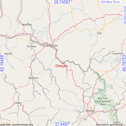
Chelyan GPS coordinates[2]
38° 11' 43.368" North, 81° 29' 27.42" West
| Map corner | latitude | longitude |
|---|---|---|
| Upper-left | 38.74587°, | -82.19408° |
| Center: | 38.19538°, | -81.49095° |
| Lower-right: | 37.6407°, | -80.78783° |
| Map W x H: | 122.9×122.9 km | = 76.4×76.4mi |
| max Lat: | 71.29058° ⇑60.7% North |
| Chelyan: | 38.19538° |
| min Lat: | ⇓39.3% South 19.06759° |
| min Long | Chelyan | max Long |
| -171.73463° | -81.49095° | -66.98998° |
| W 67.7%⇐ | ⇒32.3% E |
Elevation
Elevation of Chelyan is 187 m = 614 ft, and this is 107.8 m = 354 ft below average elevation for this country.
| Max E: |
3189 m = 10463 ft | 53.1% |
| Avg. | 294.8 m = 967 ft | |
| Chelyan | 187 m = 614 ft | |
Min E: |
-60 m = -197 ft | 46.9% |
See also: United States elevation on elevation.city.
Geographical zone
Chelyan is located in North temperate zone (between Tropic of Cancer and the Arctic Circle). Distance of this Northern Tropic circle is 1641 km =1019.7 mi to South.| Distance of | km | miles | from Chelyan |
|---|---|---|---|
| North Pole | 5760.1 | 3579.2 | to North |
| Arctic Circle | 3154.2 | 1959.9 | to North |
| Tropic Cancer | 1641 | 1019.7 | to South |
| Equator | 4246.9 | 2638.9 | to South |


Nearby cities:
15 places around Chelyan: (largest is in red/bold)
• Belle
5.8 km =3.6 mi,  315°
315°
• Boomer
18.5 km =11.5 mi,  105°
105°
• Cedar Grove
6.2 km =3.9 mi,  62°
62°
• Charleston
21.2 km =13.2 mi, 324°
• Chesapeake
5 km =3.1 mi,  308°
308°
• Coal Fork
13.8 km =8.6 mi,  349°
349°
• East Bank
4.9 km =3 mi, 58°
• Glasgow
6.2 km =3.9 mi,  69°
69°
• Marmet
8.7 km =5.4 mi, 309°
• Montgomery
14.3 km =8.9 mi,  96°
96°
• Powellton
18.1 km =11.2 mi,  126°
126°
• Pratt
9.5 km =5.9 mi,  80°
80°
• Rand
11.5 km =7.1 mi,  327°
327°
• Shrewsbury
2.1 km =1.3 mi,  54°
54°
• Smithers
16.1 km =10 mi, 95°
Sources, notices
• [Note1] Compared only with cities in United States existing in our database
• [Src1] Map data: © OpenStreetMap contributors (CC-BY-SA)
• [Src2] Other city data from geonames.org with taken over terms of usage.
• [Src3] Geographical zone / Annual Mean Temperature by Robert A. Rohde @ Wikipedia
