Charleston geodata
Charleston (West Virginia) is a seat of a first-order administrative division; located in United States in America/New_York (GMT-4) time zone. With population of 49,736 people, there are 956 cities with bigger population in this country. Compared to other cities in United States, 59.6% of cities are located further ↑North; 67% of cities are located further ←West and 50% of cities have lower elevation than Charleston. Note1


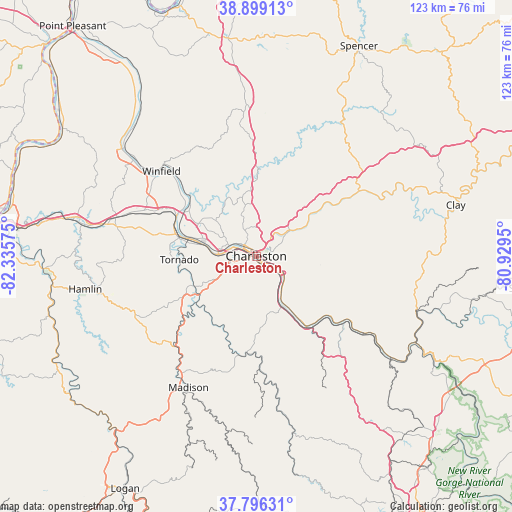
Charleston GPS coordinates[2]
38° 20' 59.352" North, 81° 37' 57.432" West
| Map corner | latitude | longitude |
|---|---|---|
| Upper-left | 38.89913°, | -82.33575° |
| Center: | 38.34982°, | -81.63262° |
| Lower-right: | 37.79631°, | -80.9295° |
| Map W x H: | 122.6×122.6 km | = 76.2×76.2mi |
| max Lat: | 71.29058° ⇑59.6% North |
| Charleston: | 38.34982° |
| min Lat: | ⇓40.4% South 19.06759° |
| min Long | Charleston | max Long |
| -171.73463° | -81.63262° | -66.98998° |
| W 67%⇐ | ⇒33% E |
Elevation
Elevation of Charleston is 198 m = 650 ft, and this is 96.8 m = 318 ft below average elevation for this country.
| Max E: |
3189 m = 10463 ft | 50% |
| Avg. | 294.8 m = 967 ft | |
| Charleston | 198 m = 650 ft | |
Min E: |
-60 m = -197 ft | 50% |
See also: Charleston elevation on elevation.city.
Geographical zone
Charleston is located in North temperate zone (between Tropic of Cancer and the Arctic Circle). Distance of this Northern Tropic circle is 1658.2 km =1030.4 mi to South.| Distance of | km | miles | from Charleston |
|---|---|---|---|
| North Pole | 5743 | 3568.5 | to North |
| Arctic Circle | 3137.1 | 1949.3 | to North |
| Tropic Cancer | 1658.2 | 1030.4 | to South |
| Equator | 4264.1 | 2649.6 | to South |


Nearby cities:
15 places around Charleston: (largest is in red/bold)
• Alum Creek
16.6 km =10.3 mi,  245°
245°
• Belle
15.5 km =9.6 mi,  147°
147°
• Big Chimney
10.5 km =6.5 mi,  53°
53°
• Chesapeake
16.4 km =10.2 mi, 149°
• Coal Fork
10.4 km =6.5 mi,  110°
110°
• Cross Lanes
15.9 km =9.9 mi,  299°
299°
• Dunbar
9.2 km =5.7 mi,  277°
277°
• Elkview
16.8 km =10.4 mi, 52°
• Jefferson
13.2 km =8.2 mi, 282°
• Marmet
12.9 km =8 mi, 153°
• Pinch
14.7 km =9.1 mi,  63°
63°
• Rand
9.7 km =6 mi,  140°
140°
• Saint Albans
18.2 km =11.3 mi, 282°
• South Charleston
6.2 km =3.9 mi,  289°
289°
• Tornado
18.5 km =11.5 mi,  267°
267°
Sources, notices
• [Note1] Compared only with cities in United States existing in our database
• [Src1] Map data: © OpenStreetMap contributors (CC-BY-SA)
• [Src2] Other city data from geonames.org with taken over terms of usage.
• [Src3] Geographical zone / Annual Mean Temperature by Robert A. Rohde @ Wikipedia
