Paw Paw geodata
Paw Paw (West Virginia) is a populated place; located in United States in America/New_York (GMT-4) time zone. With population of 508 people, there are 20785 cities with bigger population in this country. Compared to other cities in United States, 50.5% of cities are located further ↑North; 72.5% of cities are located further ←West and 71.7% of cities have lower elevation than Paw Paw. Note1


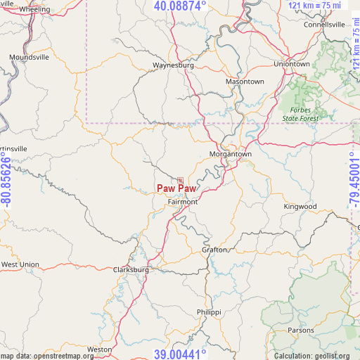
Paw Paw GPS coordinates[2]
39° 32' 55.284" North, 80° 9' 11.268" West
| Map corner | latitude | longitude |
|---|---|---|
| Upper-left | 40.08874°, | -80.85626° |
| Center: | 39.54869°, | -80.15313° |
| Lower-right: | 39.00441°, | -79.45001° |
| Map W x H: | 120.6×120.6 km | = 74.9×74.9mi |
| max Lat: | 71.29058° ⇑50.5% North |
| Paw Paw: | 39.54869° |
| min Lat: | ⇓49.5% South 19.06759° |
| min Long | Paw Paw | max Long |
| -171.73463° | -80.15313° | -66.98998° |
| W 72.5%⇐ | ⇒27.5% E |
Elevation
Elevation of Paw Paw is 294 m = 965 ft, and this is 0.80000000000001 m = 3 ft below average elevation for this country.
| Max E: |
3189 m = 10463 ft | 28.3% |
| Avg. | 294.8 m = 967 ft | |
| Paw Paw | 294 m = 965 ft | |
Min E: |
-60 m = -197 ft | 71.7% |
See also: United States elevation on elevation.city.
Geographical zone
Paw Paw is located in North temperate zone (between Tropic of Cancer and the Arctic Circle). Distance of this Northern Tropic circle is 1791.5 km =1113.2 mi to South.| Distance of | km | miles | from Paw Paw |
|---|---|---|---|
| North Pole | 5609.7 | 3485.7 | to North |
| Arctic Circle | 3003.8 | 1866.5 | to North |
| Tropic Cancer | 1791.5 | 1113.2 | to South |
| Equator | 4397.4 | 2732.4 | to South |


Nearby cities:
15 places around Paw Paw: (largest is in red/bold)
• Barrackville
5.1 km =3.2 mi,  193°
193°
• Cassville
15.1 km =9.4 mi,  30°
30°
• Enterprise
17.8 km =11.1 mi,  216°
216°
• Fairmont
7.1 km =4.4 mi,  172°
172°
• Grant Town
2.7 km =1.7 mi,  293°
293°
• Granville
17.9 km =11.1 mi,  52°
52°
• Idamay
10.6 km =6.6 mi,  237°
237°
• Mannington
16.4 km =10.2 mi,  263°
263°
• Monongah
11.1 km =6.9 mi,  210°
210°
• Morgantown
19.1 km =11.9 mi,  61°
61°
• Pleasant Valley
10.4 km =6.5 mi, 174°
• Rivesville
3.8 km =2.4 mi,  123°
123°
• Star City
18.8 km =11.7 mi, 49°
• Westover
18.4 km =11.4 mi, 58°
• White Hall
14.4 km =8.9 mi, 190°
Sources, notices
• [Note1] Compared only with cities in United States existing in our database
• [Src1] Map data: © OpenStreetMap contributors (CC-BY-SA)
• [Src2] Other city data from geonames.org with taken over terms of usage.
• [Src3] Geographical zone / Annual Mean Temperature by Robert A. Rohde @ Wikipedia
