White Hall geodata
White Hall (West Virginia) is a populated place; located in United States in America/New_York (GMT-4) time zone. With population of 663 people, there are 19039 cities with bigger population in this country. Compared to other cities in United States, 51.4% of cities are located further ↑North; 72.3% of cities are located further ←West and 79.3% of cities have lower elevation than White Hall. Note1


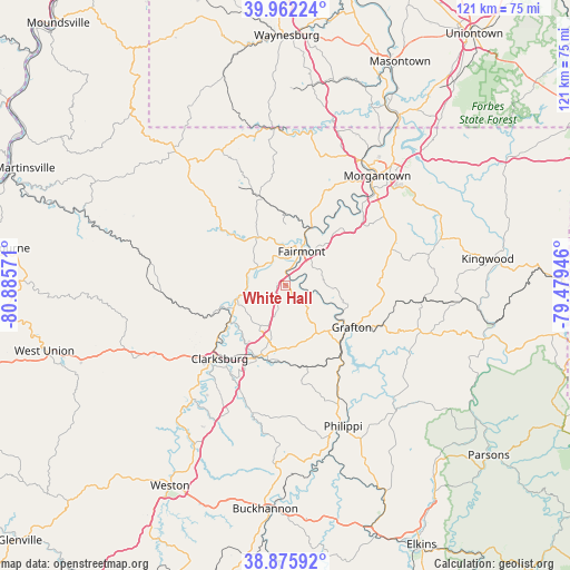
White Hall GPS coordinates[2]
39° 25' 16.32" North, 80° 10' 57.288" West
| Map corner | latitude | longitude |
|---|---|---|
| Upper-left | 39.96224°, | -80.88571° |
| Center: | 39.4212°, | -80.18258° |
| Lower-right: | 38.87592°, | -79.47946° |
| Map W x H: | 120.8×120.8 km | = 75.1×75.1mi |
| max Lat: | 71.29058° ⇑51.4% North |
| White Hall: | 39.4212° |
| min Lat: | ⇓48.6% South 19.06759° |
| min Long | White Hall | max Long |
| -171.73463° | -80.18258° | -66.98998° |
| W 72.3%⇐ | ⇒27.7% E |
Elevation
Elevation of White Hall is 347 m = 1138 ft, and this is 52.2 m = 171 ft above average elevation for this country.
| Max E: |
3189 m = 10463 ft | 20.7% |
| White Hall | 347 m 1138 ft | |
| Avg. | 294.8 m = 967 ft | |
Min E: |
-60 m = -197 ft | 79.3% |
See also: United States elevation on elevation.city.
Geographical zone
White Hall is located in North temperate zone (between Tropic of Cancer and the Arctic Circle). Distance of this Northern Tropic circle is 1777.3 km =1104.4 mi to South.| Distance of | km | miles | from White Hall |
|---|---|---|---|
| North Pole | 5623.8 | 3494.5 | to North |
| Arctic Circle | 3017.9 | 1875.2 | to North |
| Tropic Cancer | 1777.3 | 1104.4 | to South |
| Equator | 4383.2 | 2723.6 | to South |


Nearby cities:
15 places around White Hall: (largest is in red/bold)
• Barrackville
9.3 km =5.8 mi,  8°
8°
• Bethlehem
9 km =5.6 mi,  248°
248°
• Bridgeport
16.3 km =10.1 mi,  202°
202°
• Enterprise
8.2 km =5.1 mi,  269°
269°
• Fairmont
7.9 km =4.9 mi,  25°
25°
• Grafton
16.7 km =10.4 mi,  122°
122°
• Grant Town
15.2 km =9.4 mi,  0°
0°
• Hepzibah
16.4 km =10.2 mi,  233°
233°
• Idamay
10.6 km =6.6 mi,  322°
322°
• Lumberport
15.2 km =9.4 mi, 249°
• Monongah
5.5 km =3.4 mi,  326°
326°
• Paw Paw
14.4 km =8.9 mi, 10°
• Pleasant Valley
5.2 km =3.2 mi,  42°
42°
• Rivesville
13.3 km =8.3 mi, 25°
• Shinnston
10.5 km =6.5 mi, 254°
Sources, notices
• [Note1] Compared only with cities in United States existing in our database
• [Src1] Map data: © OpenStreetMap contributors (CC-BY-SA)
• [Src2] Other city data from geonames.org with taken over terms of usage.
• [Src3] Geographical zone / Annual Mean Temperature by Robert A. Rohde @ Wikipedia
