Pineville geodata
Pineville (West Virginia) is a seat of a second-order administrative division; located in United States in America/New_York (GMT-4) time zone. With population of 628 people, there are 19375 cities with bigger population in this country. Compared to other cities in United States, 63.7% of cities are located further ↑North; 67.4% of cities are located further ←West and 83.4% of cities have lower elevation than Pineville. Note1


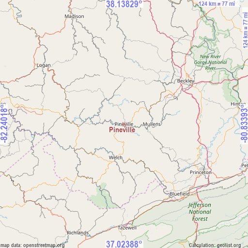
Pineville GPS coordinates[2]
37° 34' 59.412" North, 81° 32' 13.38" West
| Map corner | latitude | longitude |
|---|---|---|
| Upper-left | 38.13829°, | -82.24018° |
| Center: | 37.58317°, | -81.53705° |
| Lower-right: | 37.02388°, | -80.83393° |
| Map W x H: | 123.9×123.9 km | = 77×77mi |
| max Lat: | 71.29058° ⇑63.7% North |
| Pineville: | 37.58317° |
| min Lat: | ⇓36.3% South 19.06759° |
| min Long | Pineville | max Long |
| -171.73463° | -81.53705° | -66.98998° |
| W 67.4%⇐ | ⇒32.6% E |
Elevation
Elevation of Pineville is 396 m = 1299 ft, and this is 101.2 m = 332 ft above average elevation for this country.
| Max E: |
3189 m = 10463 ft | 16.6% |
| Pineville | 396 m 1299 ft | |
| Avg. | 294.8 m = 967 ft | |
Min E: |
-60 m = -197 ft | 83.4% |
See also: United States elevation on elevation.city.
Geographical zone
Pineville is located in North temperate zone (between Tropic of Cancer and the Arctic Circle). Distance of this Northern Tropic circle is 1572.9 km =977.4 mi to South.| Distance of | km | miles | from Pineville |
|---|---|---|---|
| North Pole | 5828.2 | 3621.5 | to North |
| Arctic Circle | 3222.3 | 2002.2 | to North |
| Tropic Cancer | 1572.9 | 977.4 | to South |
| Equator | 4178.9 | 2596.6 | to South |


Nearby cities:
15 places around Pineville: (largest is in red/bold)
• Bolt
22.7 km =14.1 mi,  28°
28°
• Bruno
31.6 km =19.6 mi,  292°
292°
• Coal City
30.7 km =19.1 mi,  69°
69°
• Crab Orchard
32.2 km =20 mi,  57°
57°
• Gary
24.4 km =15.2 mi,  182°
182°
• Gilbert Creek
31.5 km =19.6 mi,  268°
268°
• Kopperston
18.6 km =11.6 mi,  351°
351°
• Mallory
31.1 km =19.3 mi,  301°
301°
• Matheny
10.7 km =6.6 mi,  328°
328°
• Mullens
13.8 km =8.6 mi,  90°
90°
• Oceana
14.3 km =8.9 mi, 327°
• Piedmont
28.3 km =17.6 mi,  121°
121°
• Robinette
31.8 km =19.8 mi,  314°
314°
• Sophia
28.8 km =17.9 mi, 61°
• Welch
17.2 km =10.7 mi,  194°
194°
Sources, notices
• [Note1] Compared only with cities in United States existing in our database
• [Src1] Map data: © OpenStreetMap contributors (CC-BY-SA)
• [Src2] Other city data from geonames.org with taken over terms of usage.
• [Src3] Geographical zone / Annual Mean Temperature by Robert A. Rohde @ Wikipedia
