Gary geodata
Gary (West Virginia) is a populated place; located in United States in America/New_York (GMT-4) time zone. With population of 889 people, there are 17051 cities with bigger population in this country. Compared to other cities in United States, 64.6% of cities are located further ↑North; 67.3% of cities are located further ←West and 85.1% of cities have lower elevation than Gary. Note1


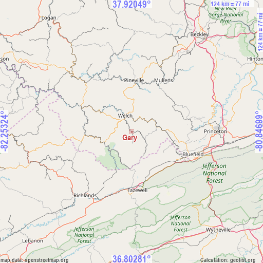
Gary GPS coordinates[2]
37° 21' 49.428" North, 81° 33' 0.396" West
| Map corner | latitude | longitude |
|---|---|---|
| Upper-left | 37.92049°, | -82.25324° |
| Center: | 37.36373°, | -81.55011° |
| Lower-right: | 36.80281°, | -80.84699° |
| Map W x H: | 124.3×124.3 km | = 77.2×77.2mi |
| max Lat: | 71.29058° ⇑64.6% North |
| Gary: | 37.36373° |
| min Lat: | ⇓35.4% South 19.06759° |
| min Long | Gary | max Long |
| -171.73463° | -81.55011° | -66.98998° |
| W 67.3%⇐ | ⇒32.7% E |
Elevation
Elevation of Gary is 427 m = 1401 ft, and this is 132.2 m = 434 ft above average elevation for this country.
| Max E: |
3189 m = 10463 ft | 14.9% |
| Gary | 427 m 1401 ft | |
| Avg. | 294.8 m = 967 ft | |
Min E: |
-60 m = -197 ft | 85.1% |
See also: United States elevation on elevation.city.
Geographical zone
Gary is located in North temperate zone (between Tropic of Cancer and the Arctic Circle). Distance of this Northern Tropic circle is 1548.5 km =962.2 mi to South.| Distance of | km | miles | from Gary |
|---|---|---|---|
| North Pole | 5852.6 | 3636.6 | to North |
| Arctic Circle | 3246.7 | 2017.4 | to North |
| Tropic Cancer | 1548.5 | 962.2 | to South |
| Equator | 4154.5 | 2581.5 | to South |


Nearby cities:
15 places around Gary: (largest is in red/bold)
• Bluefield
27.6 km =17.1 mi,  116°
116°
• Bluefield
30.8 km =19.1 mi,  109°
109°
• Bluewell
26.3 km =16.3 mi,  102°
102°
• Brush Fork
27.6 km =17.1 mi, 109°
• Cedar Bluff
35.8 km =22.2 mi,  211°
211°
• Gratton
28.2 km =17.5 mi,  154°
154°
• Matheny
33.8 km =21 mi,  352°
352°
• Montcalm
26.3 km =16.3 mi,  92°
92°
• Mullens
28.6 km =17.8 mi,  31°
31°
• Piedmont
27.1 km =16.8 mi,  69°
69°
• Pineville
24.4 km =15.2 mi,  2°
2°
• Springville
22.7 km =14.1 mi,  144°
144°
• Tazewell
27.8 km =17.3 mi,  174°
174°
• War
14.3 km =8.9 mi,  240°
240°
• Welch
8.3 km =5.2 mi,  338°
338°
Sources, notices
• [Note1] Compared only with cities in United States existing in our database
• [Src1] Map data: © OpenStreetMap contributors (CC-BY-SA)
• [Src2] Other city data from geonames.org with taken over terms of usage.
• [Src3] Geographical zone / Annual Mean Temperature by Robert A. Rohde @ Wikipedia
