Princeton geodata
Princeton (West Virginia) is a seat of a second-order administrative division; located in United States in America/New_York (GMT-4) time zone. With population of 6,035 people, there are 6379 cities with bigger population in this country. Compared to other cities in United States, 64.6% of cities are located further ↑North; 69.2% of cities are located further ←West and 91.4% of cities have lower elevation than Princeton. Note1


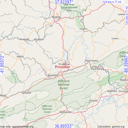
Princeton GPS coordinates[2]
37° 21' 58.428" North, 81° 6' 9.324" West
| Map corner | latitude | longitude |
|---|---|---|
| Upper-left | 37.92297°, | -81.80572° |
| Center: | 37.36623°, | -81.10259° |
| Lower-right: | 36.80533°, | -80.39947° |
| Map W x H: | 124.3×124.3 km | = 77.2×77.2mi |
| max Lat: | 71.29058° ⇑64.6% North |
| Princeton: | 37.36623° |
| min Lat: | ⇓35.4% South 19.06759° |
| min Long | Princeton | max Long |
| -171.73463° | -81.10259° | -66.98998° |
| W 69.2%⇐ | ⇒30.8% E |
Elevation
Elevation of Princeton is 744 m = 2441 ft, and this is 449.2 m = 1474 ft above average elevation for this country.
| Max E: |
3189 m = 10463 ft | 8.6% |
| Princeton | 744 m 2441 ft | |
| Avg. | 294.8 m = 967 ft | |
Min E: |
-60 m = -197 ft | 91.4% |
See also: United States elevation on elevation.city.
Geographical zone
Princeton is located in North temperate zone (between Tropic of Cancer and the Arctic Circle). Distance of this Northern Tropic circle is 1548.8 km =962.4 mi to South.| Distance of | km | miles | from Princeton |
|---|---|---|---|
| North Pole | 5852.3 | 3636.4 | to North |
| Arctic Circle | 3246.4 | 2017.2 | to North |
| Tropic Cancer | 1548.8 | 962.4 | to South |
| Equator | 4154.7 | 2581.6 | to South |


Nearby cities:
15 places around Princeton: (largest is in red/bold)
• Athens
9.9 km =6.2 mi,  50°
50°
• Bland
29.4 km =18.3 mi,  182°
182°
• Bluefield
15.1 km =9.4 mi,  224°
224°
• Bluefield
19.5 km =12.1 mi,  229°
229°
• Bluewell
15.1 km =9.4 mi,  246°
246°
• Brush Fork
16.5 km =10.3 mi,  235°
235°
• Coal City
36.1 km =22.4 mi,  344°
344°
• Montcalm
13.3 km =8.3 mi,  264°
264°
• Mullens
34.4 km =21.4 mi,  314°
314°
• Narrows
26 km =16.2 mi,  98°
98°
• Pearisburg
32.6 km =20.3 mi, 97°
• Peterstown
27 km =16.8 mi,  82°
82°
• Piedmont
17 km =10.6 mi,  303°
303°
• Rich Creek
24.8 km =15.4 mi,  85°
85°
• Springville
32.6 km =20.3 mi, 234°
Sources, notices
• [Note1] Compared only with cities in United States existing in our database
• [Src1] Map data: © OpenStreetMap contributors (CC-BY-SA)
• [Src2] Other city data from geonames.org with taken over terms of usage.
• [Src3] Geographical zone / Annual Mean Temperature by Robert A. Rohde @ Wikipedia
