Saint Albans geodata
Saint Albans (West Virginia) is a populated place; located in United States in America/New_York (GMT-4) time zone. With population of 11,044 people, there are 4167 cities with bigger population in this country. Compared to other cities in United States, 59.5% of cities are located further ↑North; 66.2% of cities are located further ←West and 53.6% of cities have higher elevation than Saint Albans. Note1


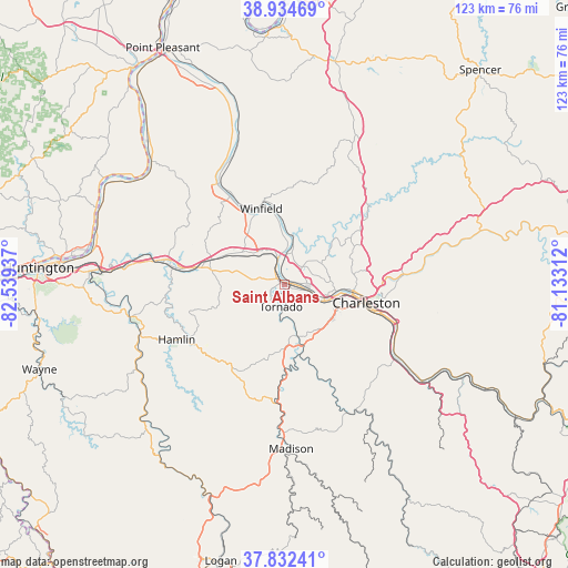
Saint Albans GPS coordinates[2]
38° 23' 8.34" North, 81° 50' 10.464" West
| Map corner | latitude | longitude |
|---|---|---|
| Upper-left | 38.93469°, | -82.53937° |
| Center: | 38.38565°, | -81.83624° |
| Lower-right: | 37.83241°, | -81.13312° |
| Map W x H: | 122.6×122.6 km | = 76.2×76.2mi |
| max Lat: | 71.29058° ⇑59.5% North |
| Saint Albans: | 38.38565° |
| min Lat: | ⇓40.5% South 19.06759° |
| min Long | Saint Albans | max Long |
| -171.73463° | -81.83624° | -66.98998° |
| W 66.2%⇐ | ⇒33.8% E |
Elevation
Elevation of Saint Albans is 185 m = 607 ft, and this is 109.8 m = 360 ft below average elevation for this country.
| Max E: |
3189 m = 10463 ft | 53.6% |
| Avg. | 294.8 m = 967 ft | |
| Saint Albans | 185 m = 607 ft | |
Min E: |
-60 m = -197 ft | 46.4% |
See also: United States elevation on elevation.city.
Geographical zone
Saint Albans is located in North temperate zone (between Tropic of Cancer and the Arctic Circle). Distance of this Northern Tropic circle is 1662.2 km =1032.8 mi to South.| Distance of | km | miles | from Saint Albans |
|---|---|---|---|
| North Pole | 5739 | 3566 | to North |
| Arctic Circle | 3133.1 | 1946.8 | to North |
| Tropic Cancer | 1662.2 | 1032.8 | to South |
| Equator | 4268.1 | 2652.1 | to South |


Nearby cities:
15 places around Saint Albans: (largest is in red/bold)
• Alum Creek
11.3 km =7 mi,  166°
166°
• Bancroft
13.8 km =8.6 mi,  358°
358°
• Charleston
18.2 km =11.3 mi,  102°
102°
• Cross Lanes
5.5 km =3.4 mi,  45°
45°
• Dunbar
9.1 km =5.7 mi,  107°
107°
• Eleanor
18.9 km =11.7 mi,  333°
333°
• Hometown
16.5 km =10.3 mi,  352°
352°
• Hurricane
16.9 km =10.5 mi,  288°
288°
• Jefferson
5 km =3.1 mi, 103°
• Nitro
3.3 km =2.1 mi, 348°
• Poca
9.8 km =6.1 mi,  11°
11°
• South Charleston
12.1 km =7.5 mi, 99°
• Teays Valley
10.8 km =6.7 mi,  311°
311°
• Tornado
4.8 km =3 mi,  188°
188°
• Winfield
17.1 km =10.6 mi,  343°
343°
Sources, notices
• [Note1] Compared only with cities in United States existing in our database
• [Src1] Map data: © OpenStreetMap contributors (CC-BY-SA)
• [Src2] Other city data from geonames.org with taken over terms of usage.
• [Src3] Geographical zone / Annual Mean Temperature by Robert A. Rohde @ Wikipedia
