Union geodata
Union (West Virginia) is a seat of a second-order administrative division; located in United States in America/New_York (GMT-4) time zone. With population of 559 people, there are 20165 cities with bigger population in this country. Compared to other cities in United States, 63.7% of cities are located further ↑North; 70.8% of cities are located further ←West and 90.1% of cities have lower elevation than Union. Note1


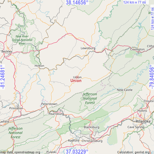
Union GPS coordinates[2]
37° 35' 29.436" North, 80° 32' 37.248" West
| Map corner | latitude | longitude |
|---|---|---|
| Upper-left | 38.14656°, | -81.24681° |
| Center: | 37.59151°, | -80.54368° |
| Lower-right: | 37.03229°, | -79.84056° |
| Map W x H: | 123.9×123.9 km | = 77×77mi |
| max Lat: | 71.29058° ⇑63.7% North |
| Union: | 37.59151° |
| min Lat: | ⇓36.3% South 19.06759° |
| min Long | Union | max Long |
| -171.73463° | -80.54368° | -66.98998° |
| W 70.8%⇐ | ⇒29.2% E |
Elevation
Elevation of Union is 631 m = 2070 ft, and this is 336.2 m = 1103 ft above average elevation for this country.
| Max E: |
3189 m = 10463 ft | 9.9% |
| Union | 631 m 2070 ft | |
| Avg. | 294.8 m = 967 ft | |
Min E: |
-60 m = -197 ft | 90.1% |
See also: United States elevation on elevation.city.
Geographical zone
Union is located in North temperate zone (between Tropic of Cancer and the Arctic Circle). Distance of this Northern Tropic circle is 1573.9 km =978 mi to South.| Distance of | km | miles | from Union |
|---|---|---|---|
| North Pole | 5827.3 | 3620.9 | to North |
| Arctic Circle | 3221.4 | 2001.7 | to North |
| Tropic Cancer | 1573.9 | 978 | to South |
| Equator | 4179.8 | 2597.2 | to South |


Nearby cities:
15 places around Union: (largest is in red/bold)
• Alderson
17.3 km =10.7 mi,  329°
329°
• Blacksburg
41.8 km =26 mi,  164°
164°
• Fairlea
22.4 km =13.9 mi,  19°
19°
• Hinton
31.8 km =19.8 mi,  286°
286°
• Lewisburg
24.9 km =15.5 mi, 20°
• Narrows
37.3 km =23.2 mi,  219°
219°
• New Castle
39.5 km =24.5 mi,  104°
104°
• Pearisburg
34 km =21.1 mi,  210°
210°
• Pembroke
31.4 km =19.5 mi,  195°
195°
• Peterstown
31.2 km =19.4 mi,  226°
226°
• Prices Fork
42.7 km =26.5 mi,  173°
173°
• Rich Creek
33.9 km =21.1 mi, 226°
• Ronceverte
19 km =11.8 mi, 22°
• Rupert
43.3 km =26.9 mi,  342°
342°
• White Sulphur Springs
31.4 km =19.5 mi,  43°
43°
Sources, notices
• [Note1] Compared only with cities in United States existing in our database
• [Src1] Map data: © OpenStreetMap contributors (CC-BY-SA)
• [Src2] Other city data from geonames.org with taken over terms of usage.
• [Src3] Geographical zone / Annual Mean Temperature by Robert A. Rohde @ Wikipedia
