Blacksburg geodata
Blacksburg (Virginia) is a populated place; located in United States in America/New_York (GMT-4) time zone. With population of 44,215 people, there are 1077 cities with bigger population in this country. Compared to other cities in United States, 65.2% of cities are located further ↑North; 71.1% of cities are located further ←West and 90.1% of cities have lower elevation than Blacksburg. Note1


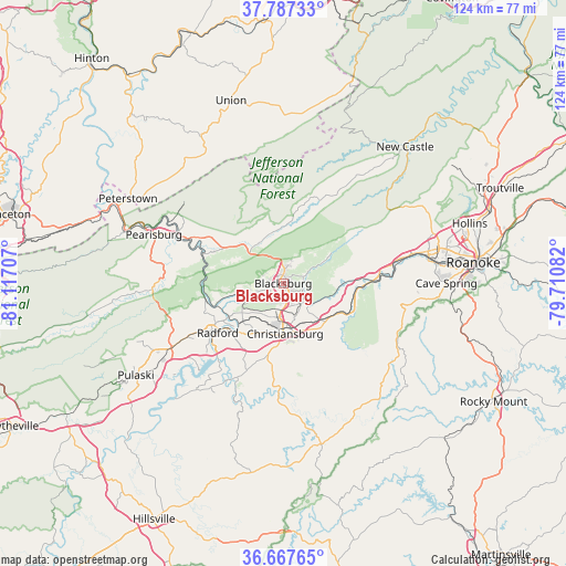
Blacksburg GPS coordinates[2]
37° 13' 46.452" North, 80° 24' 50.184" West
| Map corner | latitude | longitude |
|---|---|---|
| Upper-left | 37.78733°, | -81.11707° |
| Center: | 37.22957°, | -80.41394° |
| Lower-right: | 36.66765°, | -79.71082° |
| Map W x H: | 124.5×124.5 km | = 77.4×77.4mi |
| max Lat: | 71.29058° ⇑65.2% North |
| Blacksburg: | 37.22957° |
| min Lat: | ⇓34.8% South 19.06759° |
| min Long | Blacksburg | max Long |
| -171.73463° | -80.41394° | -66.98998° |
| W 71.1%⇐ | ⇒28.9% E |
Elevation
Elevation of Blacksburg is 631 m = 2070 ft, and this is 336.2 m = 1103 ft above average elevation for this country.
| Max E: |
3189 m = 10463 ft | 9.9% |
| Blacksburg | 631 m 2070 ft | |
| Avg. | 294.8 m = 967 ft | |
Min E: |
-60 m = -197 ft | 90.1% |
See also: Blacksburg elevation on elevation.city.
Geographical zone
Blacksburg is located in North temperate zone (between Tropic of Cancer and the Arctic Circle). Distance of this Northern Tropic circle is 1533.6 km =952.9 mi to South.| Distance of | km | miles | from Blacksburg |
|---|---|---|---|
| North Pole | 5867.5 | 3645.9 | to North |
| Arctic Circle | 3261.6 | 2026.7 | to North |
| Tropic Cancer | 1533.6 | 952.9 | to South |
| Equator | 4139.5 | 2572.2 | to South |


Nearby cities:
15 places around Blacksburg: (largest is in red/bold)
• Cave Spring
35.5 km =22.1 mi,  90°
90°
• Christiansburg
11.1 km =6.9 mi,  177°
177°
• Dublin
27.7 km =17.2 mi,  240°
240°
• Elliston
16.1 km =10 mi,  95°
95°
• Fairlawn
17.1 km =10.6 mi, 238°
• Glenvar
25.3 km =15.7 mi,  78°
78°
• Merrimac
4.6 km =2.9 mi,  193°
193°
• Pearisburg
30.6 km =19 mi,  290°
290°
• Pembroke
22.3 km =13.9 mi,  296°
296°
• Plum Creek
13.5 km =8.4 mi,  214°
214°
• Prices Fork
7.1 km =4.4 mi,  251°
251°
• Radford
18 km =11.2 mi,  232°
232°
• Riner
18.3 km =11.4 mi, 187°
• Salem
32.6 km =20.3 mi, 77°
• Shawsville
15.6 km =9.7 mi,  115°
115°
Sources, notices
• [Note1] Compared only with cities in United States existing in our database
• [Src1] Map data: © OpenStreetMap contributors (CC-BY-SA)
• [Src2] Other city data from geonames.org with taken over terms of usage.
• [Src3] Geographical zone / Annual Mean Temperature by Robert A. Rohde @ Wikipedia
