Alfred geodata
Alfred (Maine) is a seat of a second-order administrative division; located in United States in America/New_York (GMT-4) time zone. With population of 2,596 people, there are 10405 cities with bigger population in this country. Compared to other cities in United States, 86.3% of cities are located further ↓South; 98.2% of cities are located further ←West and 73% of cities have higher elevation than Alfred. Note1


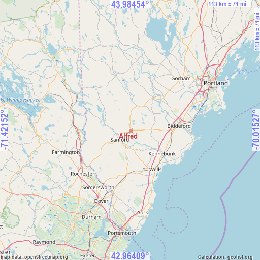
Alfred GPS coordinates[2]
43° 28' 35.292" North, 70° 43' 6.204" West
| Map corner | latitude | longitude |
|---|---|---|
| Upper-left | 43.98454°, | -71.42152° |
| Center: | 43.47647°, | -70.71839° |
| Lower-right: | 42.96409°, | -70.01527° |
| Map W x H: | 113.5×113.5 km | = 70.5×70.5mi |
| max Lat: | 71.29058° ⇑13.7% North |
| Alfred: | 43.47647° |
| min Lat: | ⇓86.3% South 19.06759° |
| min Long | Alfred | max Long |
| -171.73463° | -70.71839° | -66.98998° |
| W 98.2%⇐ | ⇒1.8% E |
Elevation
Elevation of Alfred is 83 m = 272 ft, and this is 211.8 m = 695 ft below average elevation for this country.
| Max E: |
3189 m = 10463 ft | 73% |
| Avg. | 294.8 m = 967 ft | |
| Alfred | 83 m = 272 ft | |
Min E: |
-60 m = -197 ft | 27% |
See also: United States elevation on elevation.city.
Geographical zone
Alfred is located in North temperate zone (between Tropic of Cancer and the Arctic Circle). Distance of this Northern Tropic circle is 2228.2 km =1384.5 mi to South.| Distance of | km | miles | from Alfred |
|---|---|---|---|
| North Pole | 5172.9 | 3214.3 | to North |
| Arctic Circle | 2567 | 1595.1 | to North |
| Tropic Cancer | 2228.2 | 1384.5 | to South |
| Equator | 4834.1 | 3003.8 | to South |


Nearby cities:
15 places around Alfred: (largest is in red/bold)
• Acton
16.7 km =10.4 mi,  292°
292°
• Biddeford
21.5 km =13.4 mi,  85°
85°
• Dayton
14.1 km =8.8 mi,  54°
54°
• Hollis Center
17.5 km =10.9 mi,  35°
35°
• Kennebunk
17.4 km =10.8 mi,  126°
126°
• Lake Arrowhead
20.9 km =13 mi,  356°
356°
• Lebanon
14.1 km =8.8 mi,  229°
229°
• North Berwick
19.2 km =11.9 mi,  183°
183°
• Sanford
6.1 km =3.8 mi, 227°
• Shapleigh
12.7 km =7.9 mi,  304°
304°
• South Sanford
7.5 km =4.7 mi,  195°
195°
• Springvale
6.2 km =3.9 mi,  259°
259°
• Waterboro
6.6 km =4.1 mi,  2°
2°
• Wells Beach Station
19.8 km =12.3 mi,  148°
148°
• West Kennebunk
13.4 km =8.3 mi,  124°
124°
Sources, notices
• [Note1] Compared only with cities in United States existing in our database
• [Src1] Map data: © OpenStreetMap contributors (CC-BY-SA)
• [Src2] Other city data from geonames.org with taken over terms of usage.
• [Src3] Geographical zone / Annual Mean Temperature by Robert A. Rohde @ Wikipedia
