Kennebunk geodata
Kennebunk (Maine) is a populated place; located in United States in America/New_York (GMT-4) time zone. With population of 5,214 people, there are 6983 cities with bigger population in this country. Compared to other cities in United States, 85.8% of cities are located further ↓South; 98.4% of cities are located further ←West and 86.6% of cities have higher elevation than Kennebunk. Note1


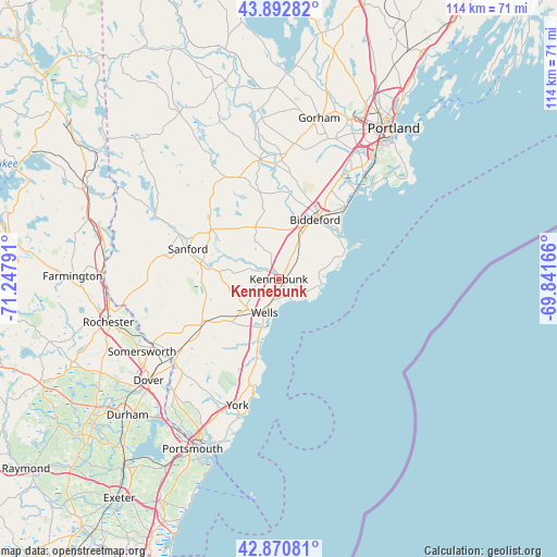
Kennebunk GPS coordinates[2]
43° 23' 2.292" North, 70° 32' 41.208" West
| Map corner | latitude | longitude |
|---|---|---|
| Upper-left | 43.89282°, | -71.24791° |
| Center: | 43.38397°, | -70.54478° |
| Lower-right: | 42.87081°, | -69.84166° |
| Map W x H: | 113.6×113.6 km | = 70.6×70.6mi |
| max Lat: | 71.29058° ⇑14.2% North |
| Kennebunk: | 43.38397° |
| min Lat: | ⇓85.8% South 19.06759° |
| min Long | Kennebunk | max Long |
| -171.73463° | -70.54478° | -66.98998° |
| W 98.4%⇐ | ⇒1.6% E |
Elevation
Elevation of Kennebunk is 24 m = 79 ft, and this is 270.8 m = 888 ft below average elevation for this country.
| Max E: |
3189 m = 10463 ft | 86.6% |
| Avg. | 294.8 m = 967 ft | |
| Kennebunk | 24 m = 79 ft | |
Min E: |
-60 m = -197 ft | 13.4% |
See also: United States elevation on elevation.city.
Geographical zone
Kennebunk is located in North temperate zone (between Tropic of Cancer and the Arctic Circle). Distance of this Northern Tropic circle is 2217.9 km =1378.1 mi to South.| Distance of | km | miles | from Kennebunk |
|---|---|---|---|
| North Pole | 5183.2 | 3220.7 | to North |
| Arctic Circle | 2577.3 | 1601.5 | to North |
| Tropic Cancer | 2217.9 | 1378.1 | to South |
| Equator | 4823.8 | 2997.4 | to South |


Nearby cities:
15 places around Kennebunk: (largest is in red/bold)
• Alfred
17.4 km =10.8 mi,  306°
306°
• Arundel
5.4 km =3.4 mi,  91°
91°
• Biddeford
14.2 km =8.8 mi,  31°
31°
• Cape Neddick
22 km =13.7 mi,  196°
196°
• Dayton
18.6 km =11.6 mi,  352°
352°
• Kennebunkport
6 km =3.7 mi,  114°
114°
• North Berwick
17.7 km =11 mi,  239°
239°
• Ogunquit
15.6 km =9.7 mi, 196°
• Old Orchard Beach
20.1 km =12.5 mi,  42°
42°
• Saco
15.4 km =9.6 mi, 32°
• Sanford
19.5 km =12.1 mi,  288°
288°
• South Sanford
16.3 km =10.1 mi,  280°
280°
• Waterboro
21.8 km =13.5 mi,  320°
320°
• Wells Beach Station
7.7 km =4.8 mi,  209°
209°
• West Kennebunk
4 km =2.5 mi, 312°
Sources, notices
• [Note1] Compared only with cities in United States existing in our database
• [Src1] Map data: © OpenStreetMap contributors (CC-BY-SA)
• [Src2] Other city data from geonames.org with taken over terms of usage.
• [Src3] Geographical zone / Annual Mean Temperature by Robert A. Rohde @ Wikipedia
