Hayti geodata
Hayti (South Dakota) is a seat of a second-order administrative division; located in United States in America/Chicago (GMT-5) time zone. With population of 381 people, there are 20944 cities with bigger population in this country. Compared to other cities in United States, 91.1% of cities are located further ↓South; 76.3% of cities are located further →East and 88.3% of cities have lower elevation than Hayti. Note1


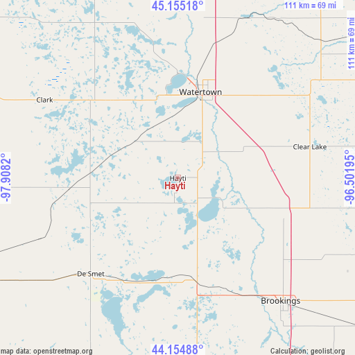
Hayti GPS coordinates[2]
44° 39' 25.884" North, 97° 12' 18.252" West
| Map corner | latitude | longitude |
|---|---|---|
| Upper-left | 45.15518°, | -97.9082° |
| Center: | 44.65719°, | -97.20507° |
| Lower-right: | 44.15488°, | -96.50195° |
| Map W x H: | 111.2×111.2 km | = 69.1×69.1mi |
| max Lat: | 71.29058° ⇑8.9% North |
| Hayti: | 44.65719° |
| min Lat: | ⇓91.1% South 19.06759° |
| min Long | Hayti | max Long |
| -171.73463° | -97.20507° | -66.98998° |
| W 23.7%⇐ | ⇒76.3% E |
Elevation
Elevation of Hayti is 517 m = 1696 ft, and this is 222.2 m = 729 ft above average elevation for this country.
| Max E: |
3189 m = 10463 ft | 11.7% |
| Hayti | 517 m 1696 ft | |
| Avg. | 294.8 m = 967 ft | |
Min E: |
-60 m = -197 ft | 88.3% |
See also: United States elevation on elevation.city.
Geographical zone
Hayti is located in North temperate zone (between Tropic of Cancer and the Arctic Circle). Distance of this Northern Tropic circle is 2359.5 km =1466.1 mi to South.| Distance of | km | miles | from Hayti |
|---|---|---|---|
| North Pole | 5041.6 | 3132.7 | to North |
| Arctic Circle | 2435.8 | 1513.5 | to North |
| Tropic Cancer | 2359.5 | 1466.1 | to South |
| Equator | 4965.4 | 3085.4 | to South |


Nearby cities:
15 places around Hayti: (largest is in red/bold)
• Arlington
33.1 km =20.6 mi,  170°
170°
• Aurora
58.5 km =36.4 mi,  135°
135°
• Brookings
50.2 km =31.2 mi, 140°
• Canby
73.6 km =45.7 mi,  85°
85°
• Castlewood
15.6 km =9.7 mi,  62°
62°
• Clark
48.4 km =30.1 mi,  300°
300°
• Clear Lake
42.5 km =26.4 mi,  76°
76°
• De Smet
40.6 km =25.2 mi,  222°
222°
• Elkton
74.1 km =46 mi,  129°
129°
• Estelline
25.7 km =16 mi,  110°
110°
• Hendricks
64 km =39.8 mi, 105°
• Lake Preston
35.4 km =22 mi,  202°
202°
• Madison
72.8 km =45.2 mi, 174°
• Volga
43.2 km =26.8 mi,  149°
149°
• Watertown
27.9 km =17.3 mi,  14°
14°
Sources, notices
• [Note1] Compared only with cities in United States existing in our database
• [Src1] Map data: © OpenStreetMap contributors (CC-BY-SA)
• [Src2] Other city data from geonames.org with taken over terms of usage.
• [Src3] Geographical zone / Annual Mean Temperature by Robert A. Rohde @ Wikipedia
