Estelline geodata
Estelline (South Dakota) is a populated place; located in United States in America/Chicago (GMT-5) time zone. With population of 756 people, there are 18168 cities with bigger population in this country. Compared to other cities in United States, 90.8% of cities are located further ↓South; 75.4% of cities are located further →East and 88% of cities have lower elevation than Estelline. Note1


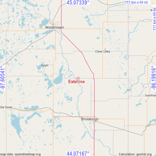
Estelline GPS coordinates[2]
44° 34' 28.884" North, 96° 54' 8.208" West
| Map corner | latitude | longitude |
|---|---|---|
| Upper-left | 45.07339°, | -97.60541° |
| Center: | 44.57469°, | -96.90228° |
| Lower-right: | 44.07167°, | -96.19916° |
| Map W x H: | 111.4×111.4 km | = 69.2×69.2mi |
| max Lat: | 71.29058° ⇑9.2% North |
| Estelline: | 44.57469° |
| min Lat: | ⇓90.8% South 19.06759° |
| min Long | Estelline | max Long |
| -171.73463° | -96.90228° | -66.98998° |
| W 24.6%⇐ | ⇒75.4% E |
Elevation
Elevation of Estelline is 506 m = 1660 ft, and this is 211.2 m = 693 ft above average elevation for this country.
| Max E: |
3189 m = 10463 ft | 12% |
| Estelline | 506 m 1660 ft | |
| Avg. | 294.8 m = 967 ft | |
Min E: |
-60 m = -197 ft | 88% |
See also: United States elevation on elevation.city.
Geographical zone
Estelline is located in North temperate zone (between Tropic of Cancer and the Arctic Circle). Distance of this Northern Tropic circle is 2350.3 km =1460.4 mi to South.| Distance of | km | miles | from Estelline |
|---|---|---|---|
| North Pole | 5050.8 | 3138.4 | to North |
| Arctic Circle | 2444.9 | 1519.2 | to North |
| Tropic Cancer | 2350.3 | 1460.4 | to South |
| Equator | 4956.2 | 3079.6 | to South |


Nearby cities:
15 places around Estelline: (largest is in red/bold)
• Arlington
29.7 km =18.5 mi,  218°
218°
• Aurora
36.6 km =22.7 mi,  151°
151°
• Brookings
30.4 km =18.9 mi,  164°
164°
• Canby
51.7 km =32.1 mi,  73°
73°
• Castlewood
19.3 km =12 mi,  328°
328°
• Clear Lake
25.8 km =16 mi,  42°
42°
• De Smet
55.5 km =34.5 mi,  247°
247°
• Elkton
50.4 km =31.3 mi,  138°
138°
• Hayti
25.7 km =16 mi,  290°
290°
• Hendricks
38.6 km =24 mi,  101°
101°
• Ivanhoe
53.4 km =33.2 mi, 103°
• Lake Benton
60 km =37.3 mi,  125°
125°
• Lake Preston
44.4 km =27.6 mi,  238°
238°
• Volga
28 km =17.4 mi,  183°
183°
• Watertown
39.8 km =24.7 mi,  335°
335°
Sources, notices
• [Note1] Compared only with cities in United States existing in our database
• [Src1] Map data: © OpenStreetMap contributors (CC-BY-SA)
• [Src2] Other city data from geonames.org with taken over terms of usage.
• [Src3] Geographical zone / Annual Mean Temperature by Robert A. Rohde @ Wikipedia
