Groton geodata
Groton (Connecticut) is a populated place; located in United States in America/New_York (GMT-4) time zone. With population of 9,221 people, there are 4724 cities with bigger population in this country. Compared to other cities in United States, 69.3% of cities are located further ↓South; 95.6% of cities are located further ←West and 85.1% of cities have higher elevation than Groton. Note1


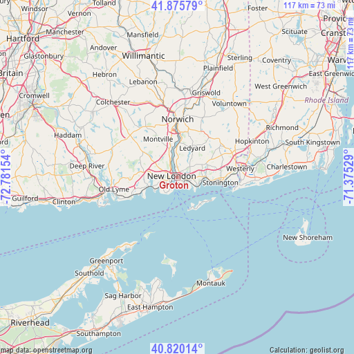
Groton GPS coordinates[2]
41° 21' 0.36" North, 72° 4' 42.276" West
| Map corner | latitude | longitude |
|---|---|---|
| Upper-left | 41.87579°, | -72.78154° |
| Center: | 41.3501°, | -72.07841° |
| Lower-right: | 40.82014°, | -71.37529° |
| Map W x H: | 117.4×117.4 km | = 72.9×72.9mi |
| max Lat: | 71.29058° ⇑30.7% North |
| Groton: | 41.3501° |
| min Lat: | ⇓69.3% South 19.06759° |
| min Long | Groton | max Long |
| -171.73463° | -72.07841° | -66.98998° |
| W 95.6%⇐ | ⇒4.4% E |
Elevation
Elevation of Groton is 28 m = 92 ft, and this is 266.8 m = 875 ft below average elevation for this country.
| Max E: |
3189 m = 10463 ft | 85.1% |
| Avg. | 294.8 m = 967 ft | |
| Groton | 28 m = 92 ft | |
Min E: |
-60 m = -197 ft | 14.9% |
See also: United States elevation on elevation.city.
Geographical zone
Groton is located in North temperate zone (between Tropic of Cancer and the Arctic Circle). Distance of this Northern Tropic circle is 1991.8 km =1237.6 mi to South.| Distance of | km | miles | from Groton |
|---|---|---|---|
| North Pole | 5409.4 | 3361.2 | to North |
| Arctic Circle | 2803.5 | 1742 | to North |
| Tropic Cancer | 1991.8 | 1237.6 | to South |
| Equator | 4597.7 | 2856.9 | to South |


Nearby cities:
15 places around Groton: (largest is in red/bold)
• Central Waterford
4.3 km =2.7 mi,  262°
262°
• Conning Towers-Nautilus Park
4 km =2.5 mi,  11°
11°
• Gales Ferry
8.9 km =5.5 mi,  358°
358°
• Groton Long Point
7.1 km =4.4 mi,  123°
123°
• Ledyard
11.3 km =7 mi,  28°
28°
• Long Hill
2.2 km =1.4 mi,  78°
78°
• Mystic
9.4 km =5.8 mi,  87°
87°
• New London
1.9 km =1.2 mi,  289°
289°
• Niantic
10 km =6.2 mi,  253°
253°
• Noank
7.7 km =4.8 mi,  108°
108°
• Old Mystic
10.8 km =6.7 mi,  64°
64°
• Oxoboxo River
11.1 km =6.9 mi,  339°
339°
• Poquonock Bridge
4.5 km =2.8 mi,  97°
97°
• Uncasville
9.7 km =6 mi, 344°
• Waterford
4.9 km =3 mi, 258°
Sources, notices
• [Note1] Compared only with cities in United States existing in our database
• [Src1] Map data: © OpenStreetMap contributors (CC-BY-SA)
• [Src2] Other city data from geonames.org with taken over terms of usage.
• [Src3] Geographical zone / Annual Mean Temperature by Robert A. Rohde @ Wikipedia
