Conning Towers-Nautilus Park geodata
Conning Towers-Nautilus Park (Connecticut) is a populated place; located in United States in America/New_York (GMT-4) time zone. With population of 8,834 people, there are 4873 cities with bigger population in this country. Compared to other cities in United States, 69.6% of cities are located further ↓South; 95.6% of cities are located further ←West and 75.3% of cities have higher elevation than Conning Towers-Nautilus Park. Note1
Current local time in Conning Towers-Nautilus Park:
02:43 PM, TuesdayDifference from your time zone: hours


Conning Towers-Nautilus Park GPS coordinates[2]
41° 23' 7.728" North, 72° 4' 7.572" West
| Map corner | latitude | longitude |
|---|---|---|
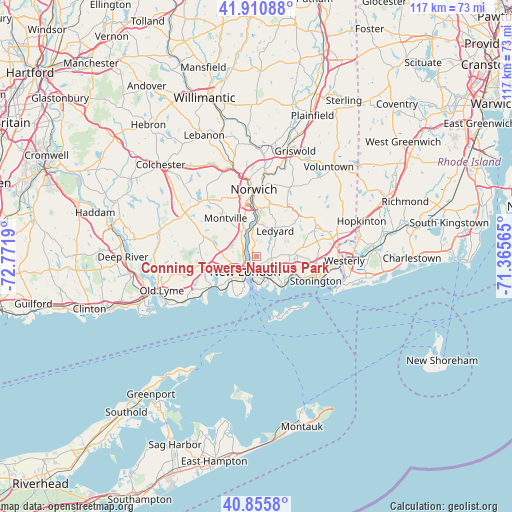
| Upper-left | 41.91088°, | -72.7719° |
| Center: | 41.38548°, | -72.06877° |
| Lower-right: | 40.8558°, | -71.36565° |
| Map W x H: | 117.3×117.3 km | = 72.9×72.9mi |
| max Lat: | 71.29058° ⇑30.4% North |
| Conning Towers-Nautilus Park: | 41.38548° |
| min Lat: | ⇓69.6% South 19.06759° |
| min Long | Conning Towers- | max Long |
| -171.73463° | -72.06877° | -66.98998° |
| W 95.6%⇐ | ⇒4.4% E |
Elevation
Elevation of Conning Towers-Nautilus Park is 70 m = 230 ft, and this is 224.8 m = 738 ft below average elevation for this country.
| Max E: |
3189 m = 10463 ft | 75.3% |
| Avg. | 294.8 m = 967 ft | |
| Conning Towers-Nautilus Park | 70 m = 230 ft | |
Min E: |
-60 m = -197 ft | 24.7% |
See also: United States elevation on elevation.city.
Geographical zone
Conning Towers-Nautilus Park is located in North temperate zone (between Tropic of Cancer and the Arctic Circle). Distance of this Northern Tropic circle is 1995.7 km =1240.1 mi to South.| Distance of | km | miles | from Conning Towers-Nautilus Park |
|---|---|---|---|
| North Pole | 5405.4 | 3358.8 | to North |
| Arctic Circle | 2799.5 | 1739.5 | to North |
| Tropic Cancer | 1995.7 | 1240.1 | to South |
| Equator | 4601.6 | 2859.3 | to South |


Nearby cities:
15 places around Conning Towers-Nautilus Park: (largest is in red/bold)
• Central Waterford
6.8 km =4.2 mi,  228°
228°
• Gales Ferry
5.1 km =3.2 mi,  347°
347°
• Groton
4 km =2.5 mi,  191°
191°
• Groton Long Point
9.4 km =5.8 mi,  147°
147°
• Ledyard
7.6 km =4.7 mi,  36°
36°
• Long Hill
3.8 km =2.4 mi,  158°
158°
• Mystic
9.2 km =5.7 mi,  112°
112°
• New London
4.2 km =2.6 mi,  217°
217°
• Niantic
12.3 km =7.6 mi,  237°
237°
• Noank
9.1 km =5.7 mi,  134°
134°
• Old Mystic
9 km =5.6 mi,  85°
85°
• Oxoboxo River
8 km =5 mi,  324°
324°
• Poquonock Bridge
5.8 km =3.6 mi,  140°
140°
• Uncasville
6.4 km =4 mi,  327°
327°
• Waterford
7.4 km =4.6 mi, 229°
Sources, notices
• [Note1] Compared only with cities in United States existing in our database
• [Src1] Map data: © OpenStreetMap contributors (CC-BY-SA)
• [Src2] Other city data from geonames.org with taken over terms of usage.
• [Src3] Geographical zone / Annual Mean Temperature by Robert A. Rohde @ Wikipedia
