Hamden geodata
Hamden (Connecticut) is a populated place; located in United States in America/New_York (GMT-4) time zone. With population of 59,847 people, there are 751 cities with bigger population in this country. Compared to other cities in United States, 69.7% of cities are located further ↓South; 94.1% of cities are located further ←West and 83.8% of cities have higher elevation than Hamden. Note1


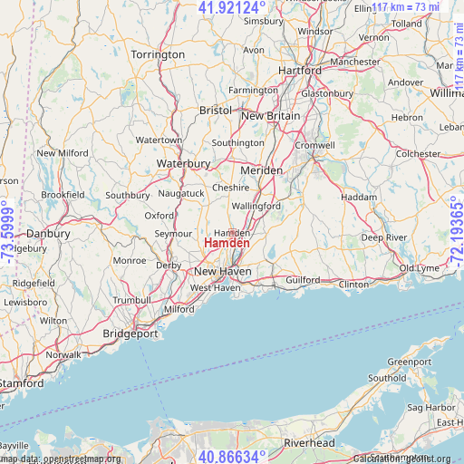
Hamden GPS coordinates[2]
41° 23' 45.348" North, 72° 53' 48.372" West
| Map corner | latitude | longitude |
|---|---|---|
| Upper-left | 41.92124°, | -73.5999° |
| Center: | 41.39593°, | -72.89677° |
| Lower-right: | 40.86634°, | -72.19365° |
| Map W x H: | 117.3×117.3 km | = 72.9×72.9mi |
| max Lat: | 71.29058° ⇑30.3% North |
| Hamden: | 41.39593° |
| min Lat: | ⇓69.7% South 19.06759° |
| min Long | Hamden | max Long |
| -171.73463° | -72.89677° | -66.98998° |
| W 94.1%⇐ | ⇒5.9% E |
Elevation
Elevation of Hamden is 32 m = 105 ft, and this is 262.8 m = 862 ft below average elevation for this country.
| Max E: |
3189 m = 10463 ft | 83.8% |
| Avg. | 294.8 m = 967 ft | |
| Hamden | 32 m = 105 ft | |
Min E: |
-60 m = -197 ft | 16.2% |
See also: Hamden elevation on elevation.city.
Geographical zone
Hamden is located in North temperate zone (between Tropic of Cancer and the Arctic Circle). Distance of this Northern Tropic circle is 1996.9 km =1240.8 mi to South.| Distance of | km | miles | from Hamden |
|---|---|---|---|
| North Pole | 5404.3 | 3358.1 | to North |
| Arctic Circle | 2798.4 | 1738.8 | to North |
| Tropic Cancer | 1996.9 | 1240.8 | to South |
| Equator | 4602.8 | 2860 | to South |


Nearby cities:
15 places around Hamden: (largest is in red/bold)
• Ansonia
16.2 km =10.1 mi,  250°
250°
• Branford
14.6 km =9.1 mi,  152°
152°
• Branford Center
14.8 km =9.2 mi, 152°
• Cheshire
11.5 km =7.1 mi,  358°
358°
• Cheshire Village
11.9 km =7.4 mi, 358°
• East Haven
13.5 km =8.4 mi,  169°
169°
• New Haven
10.1 km =6.3 mi,  195°
195°
• North Branford
13.2 km =8.2 mi,  125°
125°
• North Haven
3.2 km =2 mi,  100°
100°
• Prospect
13.7 km =8.5 mi,  329°
329°
• Seymour
14.9 km =9.3 mi,  270°
270°
• Wallingford
9.2 km =5.7 mi,  42°
42°
• Wallingford Center
8.8 km =5.5 mi,  47°
47°
• West Haven
14.5 km =9 mi, 196°
• Woodbridge
10.5 km =6.5 mi,  242°
242°
Sources, notices
• [Note1] Compared only with cities in United States existing in our database
• [Src1] Map data: © OpenStreetMap contributors (CC-BY-SA)
• [Src2] Other city data from geonames.org with taken over terms of usage.
• [Src3] Geographical zone / Annual Mean Temperature by Robert A. Rohde @ Wikipedia
