Hartford geodata
Hartford (Connecticut) is a seat of a first-order administrative division; located in United States in America/New_York (GMT-4) time zone. With population of 124,006 people, there are 253 cities with bigger population in this country. Compared to other cities in United States, 73.5% of cities are located further ↓South; 94.4% of cities are located further ←West and 85.4% of cities have higher elevation than Hartford. Note1


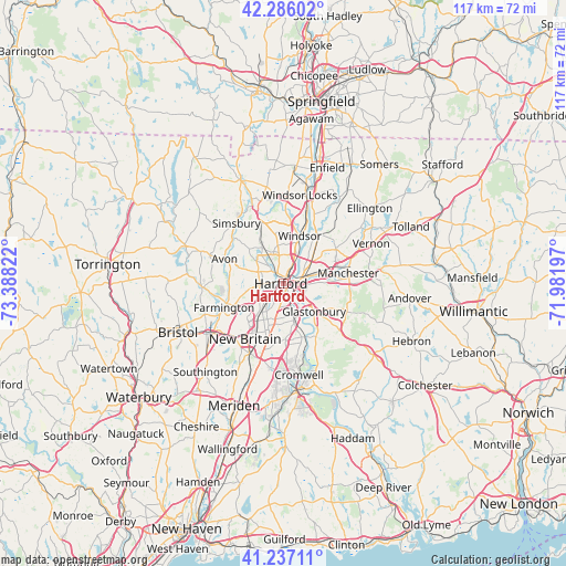
Hartford GPS coordinates[2]
41° 45' 49.356" North, 72° 41' 6.324" West
| Map corner | latitude | longitude |
|---|---|---|
| Upper-left | 42.28602°, | -73.38822° |
| Center: | 41.76371°, | -72.68509° |
| Lower-right: | 41.23711°, | -71.98197° |
| Map W x H: | 116.6×116.6 km | = 72.5×72.5mi |
| max Lat: | 71.29058° ⇑26.5% North |
| Hartford: | 41.76371° |
| min Lat: | ⇓73.5% South 19.06759° |
| min Long | Hartford | max Long |
| -171.73463° | -72.68509° | -66.98998° |
| W 94.4%⇐ | ⇒5.6% E |
Elevation
Elevation of Hartford is 27 m = 89 ft, and this is 267.8 m = 879 ft below average elevation for this country.
| Max E: |
3189 m = 10463 ft | 85.4% |
| Avg. | 294.8 m = 967 ft | |
| Hartford | 27 m = 89 ft | |
Min E: |
-60 m = -197 ft | 14.6% |
See also: Hartford elevation on elevation.city.
Geographical zone
Hartford is located in North temperate zone (between Tropic of Cancer and the Arctic Circle). Distance of this Northern Tropic circle is 2037.8 km =1266.2 mi to South.| Distance of | km | miles | from Hartford |
|---|---|---|---|
| North Pole | 5363.4 | 3332.7 | to North |
| Arctic Circle | 2757.5 | 1713.4 | to North |
| Tropic Cancer | 2037.8 | 1266.2 | to South |
| Equator | 4643.7 | 2885.5 | to South |


Nearby cities:
15 places around Hartford: (largest is in red/bold)
• Blue Hills
5.6 km =3.5 mi,  349°
349°
• East Hartford
6.4 km =4 mi,  71°
71°
• Farmington
13.1 km =8.1 mi,  248°
248°
• Glastonbury
8.6 km =5.3 mi,  131°
131°
• Glastonbury Center
10 km =6.2 mi, 134°
• Kensington
15.9 km =9.9 mi,  205°
205°
• Manchester
13.6 km =8.5 mi,  84°
84°
• New Britain
13.8 km =8.6 mi, 214°
• Newington
8 km =5 mi,  203°
203°
• Simsbury Center
16.7 km =10.4 mi,  321°
321°
• South Windsor
8.5 km =5.3 mi,  38°
38°
• Weatogue
14.8 km =9.2 mi,  306°
306°
• West Hartford
4.7 km =2.9 mi,  267°
267°
• Wethersfield
6.1 km =3.8 mi,  153°
153°
• Windsor
10.5 km =6.5 mi,  19°
19°
Sources, notices
• [Note1] Compared only with cities in United States existing in our database
• [Src1] Map data: © OpenStreetMap contributors (CC-BY-SA)
• [Src2] Other city data from geonames.org with taken over terms of usage.
• [Src3] Geographical zone / Annual Mean Temperature by Robert A. Rohde @ Wikipedia
