Middletown geodata
Middletown (Connecticut) is a populated place; located in United States in America/New_York (GMT-4) time zone. With population of 46,756 people, there are 1029 cities with bigger population in this country. Compared to other cities in United States, 71.5% of cities are located further ↓South; 94.5% of cities are located further ←West and 88.6% of cities have higher elevation than Middletown. Note1
Administrative division(s):
- Level 1: Connecticut
- Level 2: Middlesex County
- Level 3: Town of Middletown


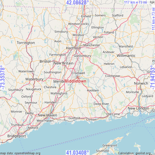
Middletown GPS coordinates[2]
41° 33' 44.352" North, 72° 39' 2.34" West
| Map corner | latitude | longitude |
|---|---|---|
| Upper-left | 42.08628°, | -73.35378° |
| Center: | 41.56232°, | -72.65065° |
| Lower-right: | 41.03408°, | -71.94753° |
| Map W x H: | 117×117 km | = 72.7×72.7mi |
| max Lat: | 71.29058° ⇑28.5% North |
| Middletown: | 41.56232° |
| min Lat: | ⇓71.5% South 19.06759° |
| min Long | Middletown | max Long |
| -171.73463° | -72.65065° | -66.98998° |
| W 94.5%⇐ | ⇒5.5% E |
Elevation
Elevation of Middletown is 19 m = 62 ft, and this is 275.8 m = 905 ft below average elevation for this country.
| Max E: |
3189 m = 10463 ft | 88.6% |
| Avg. | 294.8 m = 967 ft | |
| Middletown | 19 m = 62 ft | |
Min E: |
-60 m = -197 ft | 11.4% |
See also: Middletown elevation on elevation.city.
Geographical zone
Middletown is located in North temperate zone (between Tropic of Cancer and the Arctic Circle). Distance of this Northern Tropic circle is 2015.4 km =1252.3 mi to South.| Distance of | km | miles | from Middletown |
|---|---|---|---|
| North Pole | 5385.8 | 3346.6 | to North |
| Arctic Circle | 2779.9 | 1727.3 | to North |
| Tropic Cancer | 2015.4 | 1252.3 | to South |
| Equator | 4621.3 | 2871.5 | to South |


Nearby cities:
15 places around Middletown: (largest is in red/bold)
• Cromwell
3.7 km =2.3 mi,  6°
6°
• Durham
9.3 km =5.8 mi,  195°
195°
• East Hampton
12.4 km =7.7 mi,  82°
82°
• Glastonbury
17 km =10.6 mi, 11°
• Glastonbury Center
16 km =9.9 mi,  15°
15°
• Higganum
10.6 km =6.6 mi,  132°
132°
• Kensington
12.7 km =7.9 mi,  309°
309°
• Lake Pocotopaug
12.3 km =7.6 mi,  71°
71°
• Meriden
13.3 km =8.3 mi,  258°
258°
• Moodus
18 km =11.2 mi,  111°
111°
• New Britain
15.4 km =9.6 mi,  315°
315°
• Newington
16.2 km =10.1 mi,  338°
338°
• Portland
1.4 km =0.9 mi,  35°
35°
• Terramuggus
17 km =10.6 mi,  61°
61°
• Wethersfield
16.9 km =10.5 mi,  359°
359°
Sources, notices
• [Note1] Compared only with cities in United States existing in our database
• [Src1] Map data: © OpenStreetMap contributors (CC-BY-SA)
• [Src2] Other city data from geonames.org with taken over terms of usage.
• [Src3] Geographical zone / Annual Mean Temperature by Robert A. Rohde @ Wikipedia
