Meriden geodata
Meriden (Connecticut) is a populated place; located in United States in America/New_York (GMT-4) time zone. With population of 59,988 people, there are 748 cities with bigger population in this country. Compared to other cities in United States, 71.3% of cities are located further ↓South; 94.2% of cities are located further ←West and 78.8% of cities have higher elevation than Meriden. Note1


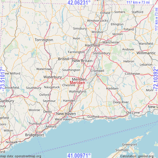
Meriden GPS coordinates[2]
41° 32' 17.34" North, 72° 48' 25.344" West
| Map corner | latitude | longitude |
|---|---|---|
| Upper-left | 42.06231°, | -73.51017° |
| Center: | 41.53815°, | -72.80704° |
| Lower-right: | 41.00971°, | -72.10392° |
| Map W x H: | 117×117 km | = 72.7×72.7mi |
| max Lat: | 71.29058° ⇑28.7% North |
| Meriden: | 41.53815° |
| min Lat: | ⇓71.3% South 19.06759° |
| min Long | Meriden | max Long |
| -171.73463° | -72.80704° | -66.98998° |
| W 94.2%⇐ | ⇒5.8% E |
Elevation
Elevation of Meriden is 52 m = 171 ft, and this is 242.8 m = 797 ft below average elevation for this country.
| Max E: |
3189 m = 10463 ft | 78.8% |
| Avg. | 294.8 m = 967 ft | |
| Meriden | 52 m = 171 ft | |
Min E: |
-60 m = -197 ft | 21.2% |
See also: Meriden elevation on elevation.city.
Geographical zone
Meriden is located in North temperate zone (between Tropic of Cancer and the Arctic Circle). Distance of this Northern Tropic circle is 2012.7 km =1250.6 mi to South.| Distance of | km | miles | from Meriden |
|---|---|---|---|
| North Pole | 5388.5 | 3348.3 | to North |
| Arctic Circle | 2782.6 | 1729 | to North |
| Tropic Cancer | 2012.7 | 1250.6 | to South |
| Equator | 4618.6 | 2869.9 | to South |


Nearby cities:
15 places around Meriden: (largest is in red/bold)
• Cheshire
8.9 km =5.5 mi,  240°
240°
• Cheshire Village
8.7 km =5.4 mi, 242°
• Cromwell
14.9 km =9.3 mi,  64°
64°
• Durham
12.2 km =7.6 mi,  120°
120°
• Hamden
17.5 km =10.9 mi,  205°
205°
• Kensington
11.3 km =7 mi,  16°
16°
• Middletown
13.3 km =8.3 mi,  78°
78°
• New Britain
13.9 km =8.6 mi,  9°
9°
• North Haven
16.9 km =10.5 mi,  194°
194°
• Plainville
15.7 km =9.8 mi,  344°
344°
• Portland
14.4 km =8.9 mi,  74°
74°
• Prospect
14.8 km =9.2 mi,  254°
254°
• Wallingford
9.1 km =5.7 mi, 188°
• Wallingford Center
9.9 km =6.2 mi, 185°
• Wolcott
16.6 km =10.3 mi,  295°
295°
Sources, notices
• [Note1] Compared only with cities in United States existing in our database
• [Src1] Map data: © OpenStreetMap contributors (CC-BY-SA)
• [Src2] Other city data from geonames.org with taken over terms of usage.
• [Src3] Geographical zone / Annual Mean Temperature by Robert A. Rohde @ Wikipedia
