Naugatuck geodata
Naugatuck (Connecticut) is a populated place; located in United States in America/New_York (GMT-4) time zone. With population of 31,538 people, there are 1575 cities with bigger population in this country. Compared to other cities in United States, 70.7% of cities are located further ↓South; 93.8% of cities are located further ←West and 76.3% of cities have higher elevation than Naugatuck. Note1
Administrative division(s):
- Level 1: Connecticut
- Level 2: New Haven County
- Level 3: Town of Naugatuck


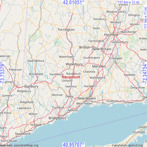
Naugatuck GPS coordinates[2]
41° 29' 9.348" North, 73° 3' 2.376" West
| Map corner | latitude | longitude |
|---|---|---|
| Upper-left | 42.01051°, | -73.75379° |
| Center: | 41.48593°, | -73.05066° |
| Lower-right: | 40.95707°, | -72.34754° |
| Map W x H: | 117.1×117.1 km | = 72.8×72.8mi |
| max Lat: | 71.29058° ⇑29.3% North |
| Naugatuck: | 41.48593° |
| min Lat: | ⇓70.7% South 19.06759° |
| min Long | Naugatuck | max Long |
| -171.73463° | -73.05066° | -66.98998° |
| W 93.8%⇐ | ⇒6.2% E |
Elevation
Elevation of Naugatuck is 64 m = 210 ft, and this is 230.8 m = 757 ft below average elevation for this country.
| Max E: |
3189 m = 10463 ft | 76.3% |
| Avg. | 294.8 m = 967 ft | |
| Naugatuck | 64 m = 210 ft | |
Min E: |
-60 m = -197 ft | 23.7% |
See also: United States elevation on elevation.city.
Geographical zone
Naugatuck is located in North temperate zone (between Tropic of Cancer and the Arctic Circle). Distance of this Northern Tropic circle is 2006.9 km =1247 mi to South.| Distance of | km | miles | from Naugatuck |
|---|---|---|---|
| North Pole | 5394.3 | 3351.9 | to North |
| Arctic Circle | 2788.4 | 1732.6 | to North |
| Tropic Cancer | 2006.9 | 1247 | to South |
| Equator | 4612.8 | 2866.3 | to South |


Nearby cities:
15 places around Naugatuck: (largest is in red/bold)
• Cheshire
12.6 km =7.8 mi,  83°
83°
• Cheshire Village
12.7 km =7.9 mi, 81°
• Heritage Village
15.6 km =9.7 mi,  269°
269°
• Middlebury
7.9 km =4.9 mi,  306°
306°
• Oakville
12.3 km =7.6 mi,  346°
346°
• Oxford
8 km =5 mi,  223°
223°
• Prospect
6.3 km =3.9 mi,  73°
73°
• Seymour
10.1 km =6.3 mi,  191°
191°
• Southbury
13.5 km =8.4 mi, 267°
• Waterbury
8 km =5 mi,  359°
359°
• Watertown
14.5 km =9 mi,  337°
337°
• Wolcott
14 km =8.7 mi,  22°
22°
• Woodbridge
15.2 km =9.4 mi,  166°
166°
• Woodbury
14.7 km =9.1 mi,  296°
296°
• Woodbury Center
14.4 km =8.9 mi, 296°
Sources, notices
• [Note1] Compared only with cities in United States existing in our database
• [Src1] Map data: © OpenStreetMap contributors (CC-BY-SA)
• [Src2] Other city data from geonames.org with taken over terms of usage.
• [Src3] Geographical zone / Annual Mean Temperature by Robert A. Rohde @ Wikipedia
