Waterbury geodata
Waterbury (Connecticut) is a populated place; located in United States in America/New_York (GMT-4) time zone. With population of 108,802 people, there are 311 cities with bigger population in this country. Compared to other cities in United States, 71.5% of cities are located further ↓South; 93.8% of cities are located further ←West and 72.8% of cities have higher elevation than Waterbury. Note1
Administrative division(s):
- Level 1: Connecticut
- Level 2: New Haven County
- Level 3: Town of Waterbury


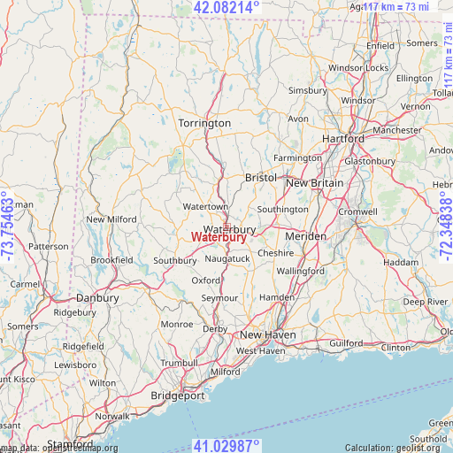
Waterbury GPS coordinates[2]
41° 33' 29.34" North, 73° 3' 5.4" West
| Map corner | latitude | longitude |
|---|---|---|
| Upper-left | 42.08214°, | -73.75463° |
| Center: | 41.55815°, | -73.0515° |
| Lower-right: | 41.02987°, | -72.34838° |
| Map W x H: | 117×117 km | = 72.7×72.7mi |
| max Lat: | 71.29058° ⇑28.5% North |
| Waterbury: | 41.55815° |
| min Lat: | ⇓71.5% South 19.06759° |
| min Long | Waterbury | max Long |
| -171.73463° | -73.0515° | -66.98998° |
| W 93.8%⇐ | ⇒6.2% E |
Elevation
Elevation of Waterbury is 84 m = 276 ft, and this is 210.8 m = 692 ft below average elevation for this country.
| Max E: |
3189 m = 10463 ft | 72.8% |
| Avg. | 294.8 m = 967 ft | |
| Waterbury | 84 m = 276 ft | |
Min E: |
-60 m = -197 ft | 27.2% |
See also: Waterbury elevation on elevation.city.
Geographical zone
Waterbury is located in North temperate zone (between Tropic of Cancer and the Arctic Circle). Distance of this Northern Tropic circle is 2014.9 km =1252 mi to South.| Distance of | km | miles | from Waterbury |
|---|---|---|---|
| North Pole | 5386.2 | 3346.8 | to North |
| Arctic Circle | 2780.3 | 1727.6 | to North |
| Tropic Cancer | 2014.9 | 1252 | to South |
| Equator | 4620.8 | 2871.2 | to South |


Nearby cities:
15 places around Waterbury: (largest is in red/bold)
• Bristol
15.2 km =9.4 mi,  33°
33°
• Cheshire
14.2 km =8.8 mi,  117°
117°
• Cheshire Village
14.1 km =8.8 mi, 116°
• Middlebury
7.2 km =4.5 mi,  242°
242°
• Naugatuck
8 km =5 mi,  179°
179°
• Oakville
4.8 km =3 mi,  324°
324°
• Oxford
14.8 km =9.2 mi,  201°
201°
• Plymouth
12.7 km =7.9 mi,  359°
359°
• Prospect
8.7 km =5.4 mi,  135°
135°
• Terryville
13.8 km =8.6 mi,  14°
14°
• Thomaston
13 km =8.1 mi,  352°
352°
• Watertown
7.7 km =4.8 mi,  313°
313°
• Wolcott
7.3 km =4.5 mi,  47°
47°
• Woodbury
13.2 km =8.2 mi,  263°
263°
• Woodbury Center
12.8 km =8 mi, 263°
Sources, notices
• [Note1] Compared only with cities in United States existing in our database
• [Src1] Map data: © OpenStreetMap contributors (CC-BY-SA)
• [Src2] Other city data from geonames.org with taken over terms of usage.
• [Src3] Geographical zone / Annual Mean Temperature by Robert A. Rohde @ Wikipedia
