Tolland geodata
Tolland (Connecticut) is a populated place; located in United States in America/New_York (GMT-4) time zone. With population of 14,891 people, there are 3260 cities with bigger population in this country. Compared to other cities in United States, 74.5% of cities are located further ↓South; 95.1% of cities are located further ←West and 52.2% of cities have lower elevation than Tolland. Note1


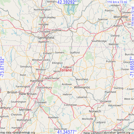
Tolland GPS coordinates[2]
41° 52' 17.364" North, 72° 22' 7.284" West
| Map corner | latitude | longitude |
|---|---|---|
| Upper-left | 42.39292°, | -73.07182° |
| Center: | 41.87149°, | -72.36869° |
| Lower-right: | 41.34577°, | -71.66557° |
| Map W x H: | 116.4×116.4 km | = 72.3×72.3mi |
| max Lat: | 71.29058° ⇑25.5% North |
| Tolland: | 41.87149° |
| min Lat: | ⇓74.5% South 19.06759° |
| min Long | Tolland | max Long |
| -171.73463° | -72.36869° | -66.98998° |
| W 95.1%⇐ | ⇒4.9% E |
Elevation
Elevation of Tolland is 207 m = 679 ft, and this is 87.8 m = 288 ft below average elevation for this country.
| Max E: |
3189 m = 10463 ft | 47.8% |
| Avg. | 294.8 m = 967 ft | |
| Tolland | 207 m = 679 ft | |
Min E: |
-60 m = -197 ft | 52.2% |
See also: United States elevation on elevation.city.
Geographical zone
Tolland is located in North temperate zone (between Tropic of Cancer and the Arctic Circle). Distance of this Northern Tropic circle is 2049.8 km =1273.7 mi to South.| Distance of | km | miles | from Tolland |
|---|---|---|---|
| North Pole | 5351.4 | 3325.2 | to North |
| Arctic Circle | 2745.5 | 1706 | to North |
| Tropic Cancer | 2049.8 | 1273.7 | to South |
| Equator | 4655.7 | 2892.9 | to South |


Nearby cities:
15 places around Tolland: (largest is in red/bold)
• Coventry Lake
11.4 km =7.1 mi,  164°
164°
• Crystal Lake
6.7 km =4.2 mi,  353°
353°
• East Windsor
15.3 km =9.5 mi,  287°
287°
• Ellington
9.1 km =5.7 mi, 293°
• Hazardville
19.4 km =12.1 mi,  311°
311°
• Manchester
16.5 km =10.3 mi,  229°
229°
• Mansfield Center
18.4 km =11.4 mi,  129°
129°
• Mansfield City
16.2 km =10.1 mi,  136°
136°
• Rockville
6.7 km =4.2 mi,  265°
265°
• Somers
14.2 km =8.8 mi,  333°
333°
• South Coventry
12.4 km =7.7 mi,  154°
154°
• Southwood Acres
19.6 km =12.2 mi,  301°
301°
• Stafford
14.2 km =8.8 mi,  27°
27°
• Stafford Springs
10.7 km =6.6 mi, 30°
• Storrs
12.1 km =7.5 mi, 125°
Sources, notices
• [Note1] Compared only with cities in United States existing in our database
• [Src1] Map data: © OpenStreetMap contributors (CC-BY-SA)
• [Src2] Other city data from geonames.org with taken over terms of usage.
• [Src3] Geographical zone / Annual Mean Temperature by Robert A. Rohde @ Wikipedia
