Adair geodata
Adair (Iowa) is a populated place; located in United States in America/Chicago (GMT-5) time zone. With population of 728 people, there are 18421 cities with bigger population in this country. Compared to other cities in United States, 70.8% of cities are located further ↓South; 70.3% of cities are located further →East and 86.1% of cities have lower elevation than Adair. Note1


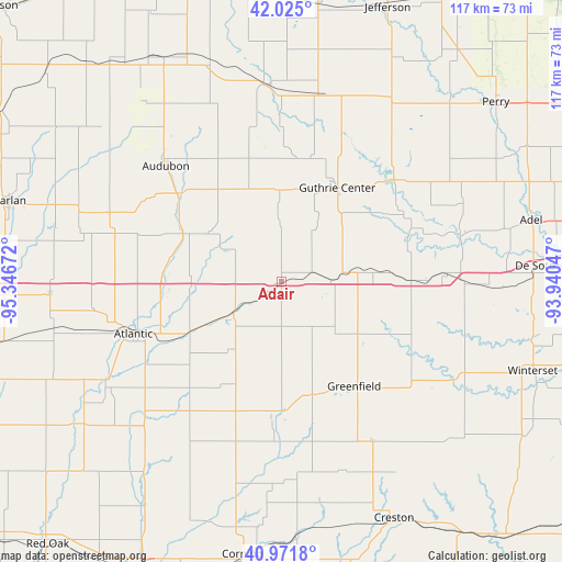
Adair GPS coordinates[2]
41° 30' 1.944" North, 94° 38' 36.924" West
| Map corner | latitude | longitude |
|---|---|---|
| Upper-left | 42.025°, | -95.34672° |
| Center: | 41.50054°, | -94.64359° |
| Lower-right: | 40.9718°, | -93.94047° |
| Map W x H: | 117.1×117.1 km | = 72.8×72.8mi |
| max Lat: | 71.29058° ⇑29.2% North |
| Adair: | 41.50054° |
| min Lat: | ⇓70.8% South 19.06759° |
| min Long | Adair | max Long |
| -171.73463° | -94.64359° | -66.98998° |
| W 29.7%⇐ | ⇒70.3% E |
Elevation
Elevation of Adair is 446 m = 1463 ft, and this is 151.2 m = 496 ft above average elevation for this country.
| Max E: |
3189 m = 10463 ft | 13.9% |
| Adair | 446 m 1463 ft | |
| Avg. | 294.8 m = 967 ft | |
Min E: |
-60 m = -197 ft | 86.1% |
See also: United States elevation on elevation.city.
Geographical zone
Adair is located in North temperate zone (between Tropic of Cancer and the Arctic Circle). Distance of this Northern Tropic circle is 2008.5 km =1248 mi to South.| Distance of | km | miles | from Adair |
|---|---|---|---|
| North Pole | 5392.6 | 3350.8 | to North |
| Arctic Circle | 2786.7 | 1731.6 | to North |
| Tropic Cancer | 2008.5 | 1248 | to South |
| Equator | 4614.4 | 2867.3 | to South |


Nearby cities:
15 places around Adair: (largest is in red/bold)
• Anita
11.8 km =7.3 mi,  238°
238°
• Atlantic
32.7 km =20.3 mi,  250°
250°
• Audubon
34.1 km =21.2 mi,  315°
315°
• Coon Rapids
41.3 km =25.7 mi,  356°
356°
• Dexter
34.8 km =21.6 mi,  86°
86°
• Earlham
43.3 km =26.9 mi, 91°
• Elk Horn
36.1 km =22.4 mi,  286°
286°
• Exira
21.8 km =13.5 mi,  297°
297°
• Fontanelle
24.4 km =15.2 mi,  163°
163°
• Greenfield
26.5 km =16.5 mi,  145°
145°
• Guthrie Center
22.8 km =14.2 mi,  30°
30°
• Lake Panorama
31.5 km =19.6 mi,  41°
41°
• Panora
31.6 km =19.6 mi,  47°
47°
• Redfield
38.5 km =23.9 mi,  75°
75°
• Stuart
27.1 km =16.8 mi, 89°
Sources, notices
• [Note1] Compared only with cities in United States existing in our database
• [Src1] Map data: © OpenStreetMap contributors (CC-BY-SA)
• [Src2] Other city data from geonames.org with taken over terms of usage.
• [Src3] Geographical zone / Annual Mean Temperature by Robert A. Rohde @ Wikipedia
