Cedar Rapids geodata
Cedar Rapids (Iowa) is a seat of a second-order administrative division; located in United States in America/Chicago (GMT-5) time zone. With population of 130,405 people, there are 232 cities with bigger population in this country. Compared to other cities in United States, 75.8% of cities are located further ↓South; 63.4% of cities are located further →East and 62.6% of cities have lower elevation than Cedar Rapids. Note1


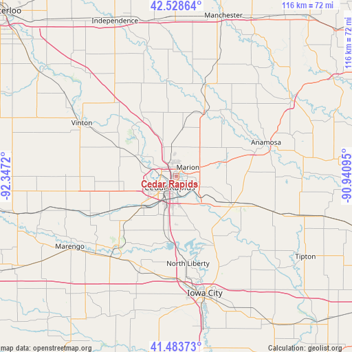
Cedar Rapids GPS coordinates[2]
42° 0' 29.988" North, 91° 38' 38.652" West
| Map corner | latitude | longitude |
|---|---|---|
| Upper-left | 42.52864°, | -92.3472° |
| Center: | 42.00833°, | -91.64407° |
| Lower-right: | 41.48373°, | -90.94095° |
| Map W x H: | 116.2×116.2 km | = 72.2×72.2mi |
| max Lat: | 71.29058° ⇑24.2% North |
| Cedar Rapids: | 42.00833° |
| min Lat: | ⇓75.8% South 19.06759° |
| min Long | Cedar Rapids | max Long |
| -171.73463° | -91.64407° | -66.98998° |
| W 36.6%⇐ | ⇒63.4% E |
Elevation
Elevation of Cedar Rapids is 251 m = 823 ft, and this is 43.8 m = 144 ft below average elevation for this country.
| Max E: |
3189 m = 10463 ft | 37.4% |
| Avg. | 294.8 m = 967 ft | |
| Cedar Rapids | 251 m = 823 ft | |
Min E: |
-60 m = -197 ft | 62.6% |
See also: Cedar Rapids elevation on elevation.city.
Geographical zone
Cedar Rapids is located in North temperate zone (between Tropic of Cancer and the Arctic Circle). Distance of this Northern Tropic circle is 2065 km =1283.1 mi to South.| Distance of | km | miles | from Cedar Rapids |
|---|---|---|---|
| North Pole | 5336.2 | 3315.8 | to North |
| Arctic Circle | 2730.3 | 1696.5 | to North |
| Tropic Cancer | 2065 | 1283.1 | to South |
| Equator | 4670.9 | 2902.4 | to South |


Nearby cities:
15 places around Cedar Rapids: (largest is in red/bold)
• Alburnett
15.7 km =9.8 mi,  7°
7°
• Atkins
18.1 km =11.2 mi,  265°
265°
• Center Point
23.4 km =14.5 mi,  330°
330°
• Ely
15.8 km =9.8 mi,  161°
161°
• Fairfax
15 km =9.3 mi,  228°
228°
• Hiawatha
4.4 km =2.7 mi,  314°
314°
• Marion
4.8 km =3 mi,  53°
53°
• Mount Vernon
21.1 km =13.1 mi,  117°
117°
• Palo
14.1 km =8.8 mi,  297°
297°
• Robins
7.2 km =4.5 mi,  344°
344°
• Shellsburg
20.9 km =13 mi, 297°
• Shueyville
17.5 km =10.9 mi,  180°
180°
• Springville
17.6 km =10.9 mi,  71°
71°
• Swisher
18.5 km =11.5 mi,  192°
192°
• Walford
21.4 km =13.3 mi, 227°
Sources, notices
• [Note1] Compared only with cities in United States existing in our database
• [Src1] Map data: © OpenStreetMap contributors (CC-BY-SA)
• [Src2] Other city data from geonames.org with taken over terms of usage.
• [Src3] Geographical zone / Annual Mean Temperature by Robert A. Rohde @ Wikipedia
