Swisher geodata
Swisher (Iowa) is a populated place; located in United States in America/Chicago (GMT-5) time zone. With population of 943 people, there are 16684 cities with bigger population in this country. Compared to other cities in United States, 74.3% of cities are located further ↓South; 63.5% of cities are located further →East and 60.1% of cities have lower elevation than Swisher. Note1


Swisher GPS coordinates[2]
41° 50' 44.016" North, 91° 41' 34.62" West
| Map corner | latitude | longitude |
|---|---|---|
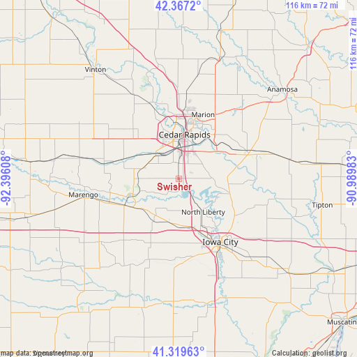
| Upper-left | 42.3672°, | -92.39608° |
| Center: | 41.84556°, | -91.69295° |
| Lower-right: | 41.31963°, | -90.98983° |
| Map W x H: | 116.5×116.5 km | = 72.4×72.4mi |
| max Lat: | 71.29058° ⇑25.7% North |
| Swisher: | 41.84556° |
| min Lat: | ⇓74.3% South 19.06759° |
| min Long | Swisher | max Long |
| -171.73463° | -91.69295° | -66.98998° |
| W 36.5%⇐ | ⇒63.5% E |
Elevation
Elevation of Swisher is 240 m = 787 ft, and this is 54.8 m = 180 ft below average elevation for this country.
| Max E: |
3189 m = 10463 ft | 39.9% |
| Avg. | 294.8 m = 967 ft | |
| Swisher | 240 m = 787 ft | |
Min E: |
-60 m = -197 ft | 60.1% |
See also: United States elevation on elevation.city.
Geographical zone
Swisher is located in North temperate zone (between Tropic of Cancer and the Arctic Circle). Distance of this Northern Tropic circle is 2046.9 km =1271.9 mi to South.| Distance of | km | miles | from Swisher |
|---|---|---|---|
| North Pole | 5354.3 | 3327 | to North |
| Arctic Circle | 2748.4 | 1707.8 | to North |
| Tropic Cancer | 2046.9 | 1271.9 | to South |
| Equator | 4652.8 | 2891.1 | to South |


Nearby cities:
15 places around Swisher: (largest is in red/bold)
• Atkins
21.9 km =13.6 mi,  320°
320°
• Cedar Rapids
18.5 km =11.5 mi,  12°
12°
• Coralville
21 km =13 mi,  153°
153°
• Ely
9.5 km =5.9 mi,  70°
70°
• Fairfax
11 km =6.8 mi, 318°
• Hiawatha
21.2 km =13.2 mi,  2°
2°
• Marion
22.4 km =13.9 mi,  20°
20°
• Middle Amana
18 km =11.2 mi,  252°
252°
• North Liberty
13.3 km =8.3 mi,  143°
143°
• Norway
20 km =12.4 mi,  288°
288°
• Oxford
15.8 km =9.8 mi,  210°
210°
• Shueyville
3.9 km =2.4 mi,  81°
81°
• Solon
17 km =10.6 mi,  104°
104°
• Tiffin
15.7 km =9.8 mi,  170°
170°
• Walford
12.3 km =7.6 mi, 287°
Sources, notices
• [Note1] Compared only with cities in United States existing in our database
• [Src1] Map data: © OpenStreetMap contributors (CC-BY-SA)
• [Src2] Other city data from geonames.org with taken over terms of usage.
• [Src3] Geographical zone / Annual Mean Temperature by Robert A. Rohde @ Wikipedia
