Conrad geodata
Conrad (Iowa) is a populated place; located in United States in America/Chicago (GMT-5) time zone. With population of 1,100 people, there are 15674 cities with bigger population in this country. Compared to other cities in United States, 77.5% of cities are located further ↓South; 66% of cities are located further →East and 74.2% of cities have lower elevation than Conrad. Note1


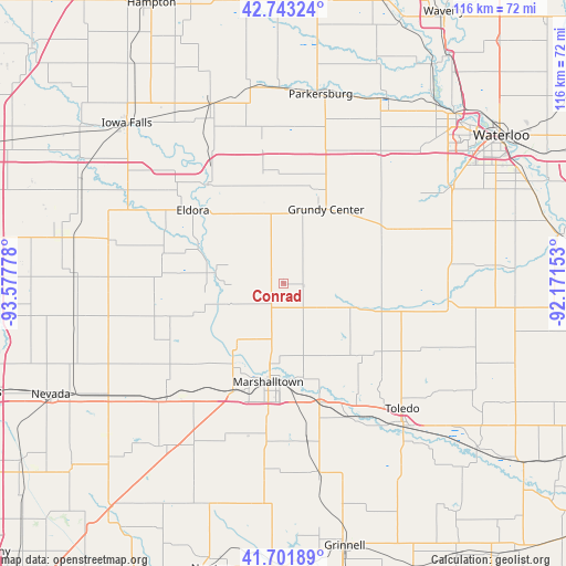
Conrad GPS coordinates[2]
42° 13' 28.956" North, 92° 52' 28.74" West
| Map corner | latitude | longitude |
|---|---|---|
| Upper-left | 42.74324°, | -93.57778° |
| Center: | 42.22471°, | -92.87465° |
| Lower-right: | 41.70189°, | -92.17153° |
| Map W x H: | 115.8×115.8 km | = 72×72mi |
| max Lat: | 71.29058° ⇑22.5% North |
| Conrad: | 42.22471° |
| min Lat: | ⇓77.5% South 19.06759° |
| min Long | Conrad | max Long |
| -171.73463° | -92.87465° | -66.98998° |
| W 34%⇐ | ⇒66% E |
Elevation
Elevation of Conrad is 308 m = 1010 ft, and this is 13.2 m = 43 ft above average elevation for this country.
| Max E: |
3189 m = 10463 ft | 25.8% |
| Conrad | 308 m 1010 ft | |
| Avg. | 294.8 m = 967 ft | |
Min E: |
-60 m = -197 ft | 74.2% |
See also: United States elevation on elevation.city.
Geographical zone
Conrad is located in North temperate zone (between Tropic of Cancer and the Arctic Circle). Distance of this Northern Tropic circle is 2089 km =1298 mi to South.| Distance of | km | miles | from Conrad |
|---|---|---|---|
| North Pole | 5312.1 | 3300.8 | to North |
| Arctic Circle | 2706.2 | 1681.6 | to North |
| Tropic Cancer | 2089 | 1298 | to South |
| Equator | 4694.9 | 2917.3 | to South |


Nearby cities:
15 places around Conrad: (largest is in red/bold)
• Dike
33.4 km =20.8 mi,  37°
37°
• Eldora
23.9 km =14.9 mi,  309°
309°
• Garwin
21.9 km =13.6 mi,  131°
131°
• Gladbrook
13.8 km =8.6 mi,  107°
107°
• Grundy Center
17.6 km =10.9 mi,  29°
29°
• Hubbard
36.2 km =22.5 mi,  284°
284°
• Le Grand
25.6 km =15.9 mi,  161°
161°
• Marshalltown
19.7 km =12.2 mi,  188°
188°
• Melbourne
36.7 km =22.8 mi,  210°
210°
• Reinbeck
25.2 km =15.7 mi,  64°
64°
• State Center
33.2 km =20.6 mi,  225°
225°
• Toledo
35.4 km =22 mi,  136°
136°
• Traer
33.9 km =21.1 mi,  95°
95°
• Wellsburg
26.6 km =16.5 mi,  348°
348°
• Zearing
35.5 km =22.1 mi,  258°
258°
Sources, notices
• [Note1] Compared only with cities in United States existing in our database
• [Src1] Map data: © OpenStreetMap contributors (CC-BY-SA)
• [Src2] Other city data from geonames.org with taken over terms of usage.
• [Src3] Geographical zone / Annual Mean Temperature by Robert A. Rohde @ Wikipedia
