De Witt geodata
De Witt (Iowa) is a populated place; located in United States in America/Chicago (GMT-5) time zone. With population of 5,242 people, there are 6960 cities with bigger population in this country. Compared to other cities in United States, 74.1% of cities are located further ↓South; 61% of cities are located further →East and 55.1% of cities have lower elevation than De Witt. Note1


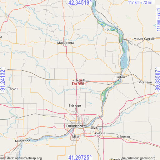
De Witt GPS coordinates[2]
41° 49' 24.096" North, 90° 32' 17.484" West
| Map corner | latitude | longitude |
|---|---|---|
| Upper-left | 42.34519°, | -91.24132° |
| Center: | 41.82336°, | -90.53819° |
| Lower-right: | 41.29725°, | -89.83507° |
| Map W x H: | 116.5×116.5 km | = 72.4×72.4mi |
| max Lat: | 71.29058° ⇑25.9% North |
| De Witt: | 41.82336° |
| min Lat: | ⇓74.1% South 19.06759° |
| min Long | De Witt | max Long |
| -171.73463° | -90.53819° | -66.98998° |
| W 39%⇐ | ⇒61% E |
Elevation
Elevation of De Witt is 219 m = 719 ft, and this is 75.8 m = 249 ft below average elevation for this country.
| Max E: |
3189 m = 10463 ft | 44.9% |
| Avg. | 294.8 m = 967 ft | |
| De Witt | 219 m = 719 ft | |
Min E: |
-60 m = -197 ft | 55.1% |
See also: United States elevation on elevation.city.
Geographical zone
De Witt is located in North temperate zone (between Tropic of Cancer and the Arctic Circle). Distance of this Northern Tropic circle is 2044.4 km =1270.3 mi to South.| Distance of | km | miles | from De Witt |
|---|---|---|---|
| North Pole | 5356.7 | 3328.5 | to North |
| Arctic Circle | 2750.9 | 1709.3 | to North |
| Tropic Cancer | 2044.4 | 1270.3 | to South |
| Equator | 4650.3 | 2889.6 | to South |


Nearby cities:
15 places around De Witt: (largest is in red/bold)
• Albany
26.7 km =16.6 mi,  98°
98°
• Camanche
23.7 km =14.7 mi, 99°
• Clinton
29 km =18 mi,  85°
85°
• Cordova
24.2 km =15 mi,  131°
131°
• Delmar
20.7 km =12.9 mi,  344°
344°
• Eldridge
18.8 km =11.7 mi,  191°
191°
• Grand Mound
9.1 km =5.7 mi,  270°
270°
• Le Claire
29.8 km =18.5 mi,  147°
147°
• Long Grove
14.5 km =9 mi, 194°
• Maquoketa
29.3 km =18.2 mi, 338°
• Park View
14.4 km =8.9 mi,  182°
182°
• Port Byron
29.4 km =18.3 mi, 145°
• Preston
27.2 km =16.9 mi,  22°
22°
• Princeton
23.3 km =14.5 mi,  135°
135°
• Wheatland
24.9 km =15.5 mi, 272°
Sources, notices
• [Note1] Compared only with cities in United States existing in our database
• [Src1] Map data: © OpenStreetMap contributors (CC-BY-SA)
• [Src2] Other city data from geonames.org with taken over terms of usage.
• [Src3] Geographical zone / Annual Mean Temperature by Robert A. Rohde @ Wikipedia
