Eldridge geodata
Eldridge (Iowa) is a populated place; located in United States in America/Chicago (GMT-5) time zone. With population of 6,232 people, there are 6252 cities with bigger population in this country. Compared to other cities in United States, 72.4% of cities are located further ↓South; 61.1% of cities are located further →East and 60.7% of cities have lower elevation than Eldridge. Note1


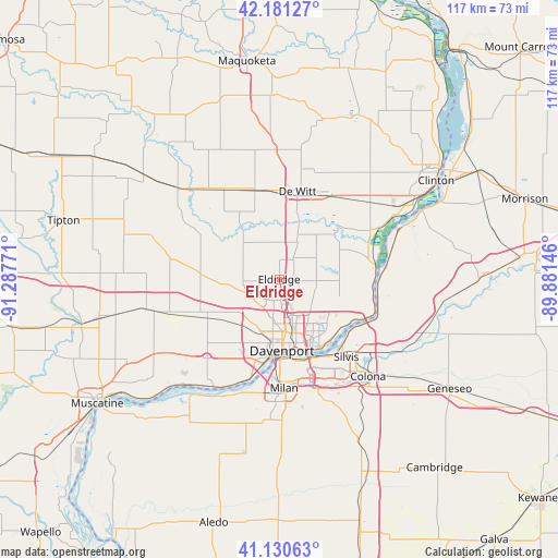
Eldridge GPS coordinates[2]
41° 39' 29.124" North, 90° 35' 4.488" West
| Map corner | latitude | longitude |
|---|---|---|
| Upper-left | 42.18127°, | -91.28771° |
| Center: | 41.65809°, | -90.58458° |
| Lower-right: | 41.13063°, | -89.88146° |
| Map W x H: | 116.8×116.8 km | = 72.6×72.6mi |
| max Lat: | 71.29058° ⇑27.6% North |
| Eldridge: | 41.65809° |
| min Lat: | ⇓72.4% South 19.06759° |
| min Long | Eldridge | max Long |
| -171.73463° | -90.58458° | -66.98998° |
| W 38.9%⇐ | ⇒61.1% E |
Elevation
Elevation of Eldridge is 243 m = 797 ft, and this is 51.8 m = 170 ft below average elevation for this country.
| Max E: |
3189 m = 10463 ft | 39.3% |
| Avg. | 294.8 m = 967 ft | |
| Eldridge | 243 m = 797 ft | |
Min E: |
-60 m = -197 ft | 60.7% |
See also: United States elevation on elevation.city.
Geographical zone
Eldridge is located in North temperate zone (between Tropic of Cancer and the Arctic Circle). Distance of this Northern Tropic circle is 2026 km =1258.9 mi to South.| Distance of | km | miles | from Eldridge |
|---|---|---|---|
| North Pole | 5375.1 | 3339.9 | to North |
| Arctic Circle | 2769.2 | 1720.7 | to North |
| Tropic Cancer | 2026 | 1258.9 | to South |
| Equator | 4631.9 | 2878.1 | to South |


Nearby cities:
15 places around Eldridge: (largest is in red/bold)
• Bettendorf
15.9 km =9.9 mi,  158°
158°
• Davenport
15 km =9.3 mi,  177°
177°
• De Witt
18.8 km =11.7 mi,  11°
11°
• East Moline
21 km =13 mi,  146°
146°
• Grand Mound
19.2 km =11.9 mi,  344°
344°
• Hampton
18.5 km =11.5 mi,  127°
127°
• Le Claire
21.1 km =13.1 mi,  108°
108°
• Long Grove
4.4 km =2.7 mi,  2°
2°
• Moline
17.8 km =11.1 mi, 161°
• Park View
5.2 km =3.2 mi,  38°
38°
• Port Byron
21.5 km =13.4 mi, 105°
• Princeton
20.4 km =12.7 mi,  84°
84°
• Rock Island
16.5 km =10.3 mi, 178°
• Silvis
21.5 km =13.4 mi,  139°
139°
• Walcott
17.6 km =10.9 mi,  242°
242°
Sources, notices
• [Note1] Compared only with cities in United States existing in our database
• [Src1] Map data: © OpenStreetMap contributors (CC-BY-SA)
• [Src2] Other city data from geonames.org with taken over terms of usage.
• [Src3] Geographical zone / Annual Mean Temperature by Robert A. Rohde @ Wikipedia
