Larchwood geodata
Larchwood (Iowa) is a populated place; located in United States in America/Chicago (GMT-5) time zone. With population of 886 people, there are 17069 cities with bigger population in this country. Compared to other cities in United States, 86.2% of cities are located further ↓South; 74.3% of cities are located further →East and 86.4% of cities have lower elevation than Larchwood. Note1


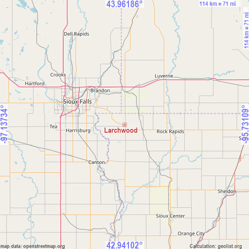
Larchwood GPS coordinates[2]
43° 27' 12.924" North, 96° 26' 3.156" West
| Map corner | latitude | longitude |
|---|---|---|
| Upper-left | 43.96186°, | -97.13734° |
| Center: | 43.45359°, | -96.43421° |
| Lower-right: | 42.94102°, | -95.73109° |
| Map W x H: | 113.5×113.5 km | = 70.5×70.5mi |
| max Lat: | 71.29058° ⇑13.8% North |
| Larchwood: | 43.45359° |
| min Lat: | ⇓86.2% South 19.06759° |
| min Long | Larchwood | max Long |
| -171.73463° | -96.43421° | -66.98998° |
| W 25.7%⇐ | ⇒74.3% E |
Elevation
Elevation of Larchwood is 451 m = 1480 ft, and this is 156.2 m = 512 ft above average elevation for this country.
| Max E: |
3189 m = 10463 ft | 13.6% |
| Larchwood | 451 m 1480 ft | |
| Avg. | 294.8 m = 967 ft | |
Min E: |
-60 m = -197 ft | 86.4% |
See also: United States elevation on elevation.city.
Geographical zone
Larchwood is located in North temperate zone (between Tropic of Cancer and the Arctic Circle). Distance of this Northern Tropic circle is 2225.7 km =1383 mi to South.| Distance of | km | miles | from Larchwood |
|---|---|---|---|
| North Pole | 5175.5 | 3215.9 | to North |
| Arctic Circle | 2569.6 | 1596.7 | to North |
| Tropic Cancer | 2225.7 | 1383 | to South |
| Equator | 4831.6 | 3002.2 | to South |


Nearby cities:
15 places around Larchwood: (largest is in red/bold)
• Brandon
19.2 km =11.9 mi,  324°
324°
• Canton
21.3 km =13.2 mi,  217°
217°
• Doon
25.3 km =15.7 mi,  139°
139°
• Garretson
29.9 km =18.6 mi,  349°
349°
• Harrisburg
21.4 km =13.3 mi,  263°
263°
• Hills
10.3 km =6.4 mi,  36°
36°
• Inwood
16.3 km =10.1 mi,  179°
179°
• Luverne
28.6 km =17.8 mi, 38°
• Meadow View Addition
29 km =18 mi,  309°
309°
• Rock Rapids
21.1 km =13.1 mi,  98°
98°
• Rock Valley
29.8 km =18.5 mi,  157°
157°
• Shindler
17.5 km =10.9 mi,  277°
277°
• Sioux Falls
24 km =14.9 mi,  296°
296°
• Valley Springs
14.6 km =9.1 mi, 349°
• Worthing
29.9 km =18.6 mi,  242°
242°
Sources, notices
• [Note1] Compared only with cities in United States existing in our database
• [Src1] Map data: © OpenStreetMap contributors (CC-BY-SA)
• [Src2] Other city data from geonames.org with taken over terms of usage.
• [Src3] Geographical zone / Annual Mean Temperature by Robert A. Rohde @ Wikipedia
