Canton geodata
Canton (South Dakota) is a seat of a second-order administrative division; located in United States in America/Chicago (GMT-5) time zone. With population of 3,331 people, there are 9093 cities with bigger population in this country. Compared to other cities in United States, 85.4% of cities are located further ↓South; 74.7% of cities are located further →East and 82.9% of cities have lower elevation than Canton. Note1


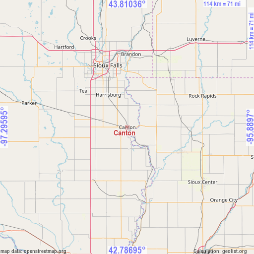
Canton GPS coordinates[2]
43° 18' 2.916" North, 96° 35' 34.152" West
| Map corner | latitude | longitude |
|---|---|---|
| Upper-left | 43.81036°, | -97.29595° |
| Center: | 43.30081°, | -96.59282° |
| Lower-right: | 42.78695°, | -95.8897° |
| Map W x H: | 113.8×113.8 km | = 70.7×70.7mi |
| max Lat: | 71.29058° ⇑14.6% North |
| Canton: | 43.30081° |
| min Lat: | ⇓85.4% South 19.06759° |
| min Long | Canton | max Long |
| -171.73463° | -96.59282° | -66.98998° |
| W 25.3%⇐ | ⇒74.7% E |
Elevation
Elevation of Canton is 389 m = 1276 ft, and this is 94.2 m = 309 ft above average elevation for this country.
| Max E: |
3189 m = 10463 ft | 17.1% |
| Canton | 389 m 1276 ft | |
| Avg. | 294.8 m = 967 ft | |
Min E: |
-60 m = -197 ft | 82.9% |
See also: United States elevation on elevation.city.
Geographical zone
Canton is located in North temperate zone (between Tropic of Cancer and the Arctic Circle). Distance of this Northern Tropic circle is 2208.7 km =1372.4 mi to South.| Distance of | km | miles | from Canton |
|---|---|---|---|
| North Pole | 5192.5 | 3226.5 | to North |
| Arctic Circle | 2586.6 | 1607.2 | to North |
| Tropic Cancer | 2208.7 | 1372.4 | to South |
| Equator | 4814.6 | 2991.7 | to South |


Nearby cities:
15 places around Canton: (largest is in red/bold)
• Alcester
31.2 km =19.4 mi,  185°
185°
• Beresford
28.5 km =17.7 mi,  210°
210°
• Brandon
32.7 km =20.3 mi,  2°
2°
• Doon
29.2 km =18.1 mi,  94°
94°
• Harrisburg
16.8 km =10.4 mi,  329°
329°
• Hills
31.6 km =19.6 mi,  36°
36°
• Inwood
13 km =8.1 mi, 86°
• Larchwood
21.3 km =13.2 mi, 37°
• Lennox
24.9 km =15.5 mi,  283°
283°
• Rock Valley
26.4 km =16.4 mi,  113°
113°
• Shindler
19.9 km =12.4 mi,  346°
346°
• Sioux Falls
29 km =18 mi,  342°
342°
• Tea
25.5 km =15.8 mi,  309°
309°
• Valley Springs
32.9 km =20.4 mi,  17°
17°
• Worthing
14.1 km =8.8 mi, 282°
Sources, notices
• [Note1] Compared only with cities in United States existing in our database
• [Src1] Map data: © OpenStreetMap contributors (CC-BY-SA)
• [Src2] Other city data from geonames.org with taken over terms of usage.
• [Src3] Geographical zone / Annual Mean Temperature by Robert A. Rohde @ Wikipedia
