Le Mars geodata
Le Mars (Iowa) is a seat of a second-order administrative division; located in United States in America/Chicago (GMT-5) time zone. With population of 9,761 people, there are 4541 cities with bigger population in this country. Compared to other cities in United States, 81.8% of cities are located further ↓South; 73.8% of cities are located further →East and 81.8% of cities have lower elevation than Le Mars. Note1


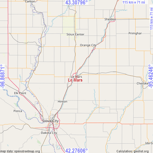
Le Mars GPS coordinates[2]
42° 47' 38.976" North, 96° 9' 56.088" West
| Map corner | latitude | longitude |
|---|---|---|
| Upper-left | 43.30796°, | -96.86871° |
| Center: | 42.79416°, | -96.16558° |
| Lower-right: | 42.27606°, | -95.46246° |
| Map W x H: | 114.7×114.7 km | = 71.3×71.3mi |
| max Lat: | 71.29058° ⇑18.2% North |
| Le Mars: | 42.79416° |
| min Lat: | ⇓81.8% South 19.06759° |
| min Long | Le Mars | max Long |
| -171.73463° | -96.16558° | -66.98998° |
| W 26.2%⇐ | ⇒73.8% E |
Elevation
Elevation of Le Mars is 374 m = 1227 ft, and this is 79.2 m = 260 ft above average elevation for this country.
| Max E: |
3189 m = 10463 ft | 18.2% |
| Le Mars | 374 m 1227 ft | |
| Avg. | 294.8 m = 967 ft | |
Min E: |
-60 m = -197 ft | 81.8% |
See also: United States elevation on elevation.city.
Geographical zone
Le Mars is located in North temperate zone (between Tropic of Cancer and the Arctic Circle). Distance of this Northern Tropic circle is 2152.3 km =1337.4 mi to South.| Distance of | km | miles | from Le Mars |
|---|---|---|---|
| North Pole | 5248.8 | 3261.5 | to North |
| Arctic Circle | 2642.9 | 1642.2 | to North |
| Tropic Cancer | 2152.3 | 1337.4 | to South |
| Equator | 4758.3 | 2956.7 | to South |


Nearby cities:
15 places around Le Mars: (largest is in red/bold)
• Akron
32.4 km =20.1 mi,  276°
276°
• Alton
24.9 km =15.5 mi,  30°
30°
• Hawarden
34.4 km =21.4 mi,  310°
310°
• Hinton
21.2 km =13.2 mi,  209°
209°
• Hospers
37.5 km =23.3 mi, 34°
• Ireton
23.6 km =14.7 mi,  328°
328°
• Kingsley
28 km =17.4 mi,  144°
144°
• Lawton
35.1 km =21.8 mi,  182°
182°
• Marcus
29.4 km =18.3 mi,  83°
83°
• Merrill
10.7 km =6.6 mi,  219°
219°
• Moville
34.8 km =21.6 mi,  167°
167°
• Orange City
25.2 km =15.7 mi,  20°
20°
• Remsen
15.8 km =9.8 mi, 81°
• Sioux Center
31.8 km =19.8 mi,  358°
358°
• Sioux City
37.9 km =23.5 mi, 210°
Sources, notices
• [Note1] Compared only with cities in United States existing in our database
• [Src1] Map data: © OpenStreetMap contributors (CC-BY-SA)
• [Src2] Other city data from geonames.org with taken over terms of usage.
• [Src3] Geographical zone / Annual Mean Temperature by Robert A. Rohde @ Wikipedia
