Akron geodata
Akron (Iowa) is a populated place; located in United States in America/Chicago (GMT-5) time zone. With population of 1,450 people, there are 13877 cities with bigger population in this country. Compared to other cities in United States, 82.1% of cities are located further ↓South; 74.6% of cities are located further →East and 79.2% of cities have lower elevation than Akron. Note1


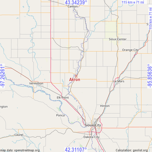
Akron GPS coordinates[2]
42° 49' 43.968" North, 96° 33' 34.128" West
| Map corner | latitude | longitude |
|---|---|---|
| Upper-left | 43.34239°, | -97.26261° |
| Center: | 42.82888°, | -96.55948° |
| Lower-right: | 42.31107°, | -95.85636° |
| Map W x H: | 114.7×114.7 km | = 71.3×71.3mi |
| max Lat: | 71.29058° ⇑17.9% North |
| Akron: | 42.82888° |
| min Lat: | ⇓82.1% South 19.06759° |
| min Long | Akron | max Long |
| -171.73463° | -96.55948° | -66.98998° |
| W 25.4%⇐ | ⇒74.6% E |
Elevation
Elevation of Akron is 346 m = 1135 ft, and this is 51.2 m = 168 ft above average elevation for this country.
| Max E: |
3189 m = 10463 ft | 20.8% |
| Akron | 346 m 1135 ft | |
| Avg. | 294.8 m = 967 ft | |
Min E: |
-60 m = -197 ft | 79.2% |
See also: United States elevation on elevation.city.
Geographical zone
Akron is located in North temperate zone (between Tropic of Cancer and the Arctic Circle). Distance of this Northern Tropic circle is 2156.2 km =1339.8 mi to South.| Distance of | km | miles | from Akron |
|---|---|---|---|
| North Pole | 5244.9 | 3259 | to North |
| Arctic Circle | 2639 | 1639.8 | to North |
| Tropic Cancer | 2156.2 | 1339.8 | to South |
| Equator | 4762.1 | 2959 | to South |


Nearby cities:
15 places around Akron: (largest is in red/bold)
• Alcester
22.2 km =13.8 mi,  344°
344°
• Beresford
33 km =20.5 mi,  328°
328°
• Dakota Dunes
38.4 km =23.9 mi,  171°
171°
• Elk Point
19.1 km =11.9 mi,  212°
212°
• Hawarden
19.5 km =12.1 mi,  18°
18°
• Hinton
31.3 km =19.4 mi,  135°
135°
• Ireton
25.5 km =15.8 mi,  50°
50°
• Jefferson
25.2 km =15.7 mi,  179°
179°
• Le Mars
32.4 km =20.1 mi,  96°
96°
• Merrill
28.1 km =17.5 mi,  115°
115°
• North Sioux City
34.1 km =21.2 mi, 169°
• Ponca
31.9 km =19.8 mi,  201°
201°
• Sioux City
38.8 km =24.1 mi,  160°
160°
• South Sioux City
41.2 km =25.6 mi, 163°
• Vermillion
30.7 km =19.1 mi,  259°
259°
Sources, notices
• [Note1] Compared only with cities in United States existing in our database
• [Src1] Map data: © OpenStreetMap contributors (CC-BY-SA)
• [Src2] Other city data from geonames.org with taken over terms of usage.
• [Src3] Geographical zone / Annual Mean Temperature by Robert A. Rohde @ Wikipedia
