Middle Amana geodata
Middle Amana (Iowa) is a populated place; located in United States in America/Chicago (GMT-5) time zone. With population of 581 people, there are 19902 cities with bigger population in this country. Compared to other cities in United States, 73.9% of cities are located further ↓South; 63.9% of cities are located further →East and 58.4% of cities have lower elevation than Middle Amana. Note1


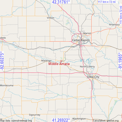
Middle Amana GPS coordinates[2]
41° 47' 44.016" North, 91° 53' 58.632" West
| Map corner | latitude | longitude |
|---|---|---|
| Upper-left | 42.31761°, | -92.60275° |
| Center: | 41.79556°, | -91.89962° |
| Lower-right: | 41.26922°, | -91.1965° |
| Map W x H: | 116.6×116.6 km | = 72.5×72.5mi |
| max Lat: | 71.29058° ⇑26.1% North |
| Middle Amana: | 41.79556° |
| min Lat: | ⇓73.9% South 19.06759° |
| min Long | Middle Amana | max Long |
| -171.73463° | -91.89962° | -66.98998° |
| W 36.1%⇐ | ⇒63.9% E |
Elevation
Elevation of Middle Amana is 232 m = 761 ft, and this is 62.8 m = 206 ft below average elevation for this country.
| Max E: |
3189 m = 10463 ft | 41.6% |
| Avg. | 294.8 m = 967 ft | |
| Middle Amana | 232 m = 761 ft | |
Min E: |
-60 m = -197 ft | 58.4% |
See also: United States elevation on elevation.city.
Geographical zone
Middle Amana is located in North temperate zone (between Tropic of Cancer and the Arctic Circle). Distance of this Northern Tropic circle is 2041.3 km =1268.4 mi to South.| Distance of | km | miles | from Middle Amana |
|---|---|---|---|
| North Pole | 5359.8 | 3330.4 | to North |
| Arctic Circle | 2753.9 | 1711.2 | to North |
| Tropic Cancer | 2041.3 | 1268.4 | to South |
| Equator | 4647.2 | 2887.6 | to South |


Nearby cities:
15 places around Middle Amana: (largest is in red/bold)
• Atkins
22.6 km =14 mi,  7°
7°
• Blairstown
19.9 km =12.4 mi,  309°
309°
• Ely
27.5 km =17.1 mi,  71°
71°
• Fairfax
16.9 km =10.5 mi,  35°
35°
• Marengo
14.2 km =8.8 mi,  271°
271°
• Newhall
22.9 km =14.2 mi,  345°
345°
• North Liberty
25.5 km =15.8 mi,  101°
101°
• Norway
12.1 km =7.5 mi, 351°
• Oxford
12.1 km =7.5 mi,  131°
131°
• Shueyville
21.8 km =13.5 mi, 73°
• Swisher
18 km =11.2 mi, 72°
• Tiffin
22 km =13.7 mi,  116°
116°
• Van Horne
28.5 km =17.7 mi,  326°
326°
• Walford
10.7 km =6.6 mi,  30°
30°
• Williamsburg
17.5 km =10.9 mi,  211°
211°
Sources, notices
• [Note1] Compared only with cities in United States existing in our database
• [Src1] Map data: © OpenStreetMap contributors (CC-BY-SA)
• [Src2] Other city data from geonames.org with taken over terms of usage.
• [Src3] Geographical zone / Annual Mean Temperature by Robert A. Rohde @ Wikipedia
