West Branch geodata
West Branch (Iowa) is a populated place; located in United States in America/Chicago (GMT-5) time zone. With population of 2,337 people, there are 11000 cities with bigger population in this country. Compared to other cities in United States, 72.6% of cities are located further ↓South; 62.8% of cities are located further →East and 55.8% of cities have lower elevation than West Branch. Note1


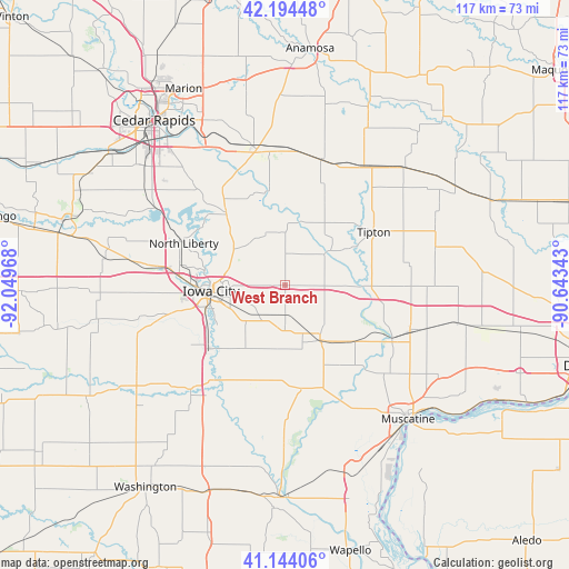
West Branch GPS coordinates[2]
41° 40' 17.076" North, 91° 20' 47.58" West
| Map corner | latitude | longitude |
|---|---|---|
| Upper-left | 42.19448°, | -92.04968° |
| Center: | 41.67141°, | -91.34655° |
| Lower-right: | 41.14406°, | -90.64343° |
| Map W x H: | 116.8×116.8 km | = 72.6×72.6mi |
| max Lat: | 71.29058° ⇑27.4% North |
| West Branch: | 41.67141° |
| min Lat: | ⇓72.6% South 19.06759° |
| min Long | West Branch | max Long |
| -171.73463° | -91.34655° | -66.98998° |
| W 37.2%⇐ | ⇒62.8% E |
Elevation
Elevation of West Branch is 222 m = 728 ft, and this is 72.8 m = 239 ft below average elevation for this country.
| Max E: |
3189 m = 10463 ft | 44.2% |
| Avg. | 294.8 m = 967 ft | |
| West Branch | 222 m = 728 ft | |
Min E: |
-60 m = -197 ft | 55.8% |
See also: United States elevation on elevation.city.
Geographical zone
West Branch is located in North temperate zone (between Tropic of Cancer and the Arctic Circle). Distance of this Northern Tropic circle is 2027.5 km =1259.8 mi to South.| Distance of | km | miles | from West Branch |
|---|---|---|---|
| North Pole | 5373.6 | 3339 | to North |
| Arctic Circle | 2767.7 | 1719.8 | to North |
| Tropic Cancer | 2027.5 | 1259.8 | to South |
| Equator | 4633.4 | 2879.1 | to South |


Nearby cities:
15 places around West Branch: (largest is in red/bold)
• Coralville
19.4 km =12.1 mi,  271°
271°
• Hills
20.4 km =12.7 mi,  230°
230°
• Iowa City
15.3 km =9.5 mi, 265°
• Lisbon
28 km =17.4 mi,  353°
353°
• Lone Tree
21.4 km =13.3 mi,  197°
197°
• Mechanicsville
27 km =16.8 mi,  16°
16°
• Mount Vernon
28.5 km =17.7 mi, 348°
• North Liberty
22.6 km =14 mi,  292°
292°
• Riverside
28.9 km =18 mi,  222°
222°
• Solon
19.4 km =12.1 mi,  320°
320°
• Tiffin
26.5 km =16.5 mi,  278°
278°
• Tipton
21.2 km =13.2 mi,  58°
58°
• University Heights
17.6 km =10.9 mi,  264°
264°
• West Liberty
13.2 km =8.2 mi,  148°
148°
• Wilton
28.9 km =18 mi,  108°
108°
Sources, notices
• [Note1] Compared only with cities in United States existing in our database
• [Src1] Map data: © OpenStreetMap contributors (CC-BY-SA)
• [Src2] Other city data from geonames.org with taken over terms of usage.
• [Src3] Geographical zone / Annual Mean Temperature by Robert A. Rohde @ Wikipedia
