Lone Tree geodata
Lone Tree (Iowa) is a populated place; located in United States in America/Chicago (GMT-5) time zone. With population of 1,415 people, there are 14039 cities with bigger population in this country. Compared to other cities in United States, 70.7% of cities are located further ↓South; 62.9% of cities are located further →East and 55.4% of cities have lower elevation than Lone Tree. Note1


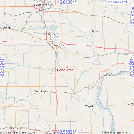
Lone Tree GPS coordinates[2]
41° 29' 17.088" North, 91° 25' 33.564" West
| Map corner | latitude | longitude |
|---|---|---|
| Upper-left | 42.01264°, | -92.12912° |
| Center: | 41.48808°, | -91.42599° |
| Lower-right: | 40.95923°, | -90.72287° |
| Map W x H: | 117.1×117.1 km | = 72.8×72.8mi |
| max Lat: | 71.29058° ⇑29.3% North |
| Lone Tree: | 41.48808° |
| min Lat: | ⇓70.7% South 19.06759° |
| min Long | Lone Tree | max Long |
| -171.73463° | -91.42599° | -66.98998° |
| W 37.1%⇐ | ⇒62.9% E |
Elevation
Elevation of Lone Tree is 220 m = 722 ft, and this is 74.8 m = 245 ft below average elevation for this country.
| Max E: |
3189 m = 10463 ft | 44.6% |
| Avg. | 294.8 m = 967 ft | |
| Lone Tree | 220 m = 722 ft | |
Min E: |
-60 m = -197 ft | 55.4% |
See also: United States elevation on elevation.city.
Geographical zone
Lone Tree is located in North temperate zone (between Tropic of Cancer and the Arctic Circle). Distance of this Northern Tropic circle is 2007.1 km =1247.2 mi to South.| Distance of | km | miles | from Lone Tree |
|---|---|---|---|
| North Pole | 5394 | 3351.7 | to North |
| Arctic Circle | 2788.1 | 1732.4 | to North |
| Tropic Cancer | 2007.1 | 1247.2 | to South |
| Equator | 4613 | 2866.4 | to South |


Nearby cities:
15 places around Lone Tree: (largest is in red/bold)
• Ainsworth
24.5 km =15.2 mi,  205°
205°
• Columbus Junction
23.8 km =14.8 mi,  166°
166°
• Coralville
24.6 km =15.3 mi,  328°
328°
• Fruitland
28.8 km =17.9 mi,  120°
120°
• Grandview
30.8 km =19.1 mi,  139°
139°
• Hills
11.7 km =7.3 mi,  309°
309°
• Iowa City
21.1 km =13.1 mi,  335°
335°
• Kalona
23.3 km =14.5 mi,  268°
268°
• North Liberty
32.4 km =20.1 mi, 333°
• Riverside
13 km =8.1 mi, 265°
• Tiffin
31.2 km =19.4 mi,  320°
320°
• University Heights
21.5 km =13.4 mi, 329°
• Washington
30.6 km =19 mi,  226°
226°
• West Branch
21.4 km =13.3 mi,  17°
17°
• West Liberty
16.3 km =10.1 mi,  55°
55°
Sources, notices
• [Note1] Compared only with cities in United States existing in our database
• [Src1] Map data: © OpenStreetMap contributors (CC-BY-SA)
• [Src2] Other city data from geonames.org with taken over terms of usage.
• [Src3] Geographical zone / Annual Mean Temperature by Robert A. Rohde @ Wikipedia
