Chicago geodata
Chicago (Illinois) is a seat of a second-order administrative division; located in United States in America/Chicago (GMT-5) time zone. With population of 2,720,546 people, there are 2 cities with bigger population in this country. Compared to other cities in United States, 74.3% of cities are located further ↓South; 51.2% of cities are located further →East and 55.1% of cities have higher elevation than Chicago. Note1


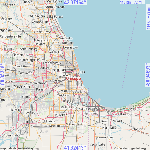
Chicago GPS coordinates[2]
41° 51' 0.108" North, 87° 39' 0.18" West
| Map corner | latitude | longitude |
|---|---|---|
| Upper-left | 42.37164°, | -88.35318° |
| Center: | 41.85003°, | -87.65005° |
| Lower-right: | 41.32413°, | -86.94693° |
| Map W x H: | 116.5×116.5 km | = 72.4×72.4mi |
| max Lat: | 71.29058° ⇑25.7% North |
| Chicago: | 41.85003° |
| min Lat: | ⇓74.3% South 19.06759° |
| min Long | Chicago | max Long |
| -171.73463° | -87.65005° | -66.98998° |
| W 48.8%⇐ | ⇒51.2% E |
Elevation
Elevation of Chicago is 180 m = 591 ft, and this is 114.8 m = 377 ft below average elevation for this country.
| Max E: |
3189 m = 10463 ft | 55.1% |
| Avg. | 294.8 m = 967 ft | |
| Chicago | 180 m = 591 ft | |
Min E: |
-60 m = -197 ft | 44.9% |
See also: Chicago elevation on elevation.city.
Geographical zone
Chicago is located in North temperate zone (between Tropic of Cancer and the Arctic Circle). Distance of this Northern Tropic circle is 2047.4 km =1272.2 mi to South.| Distance of | km | miles | from Chicago |
|---|---|---|---|
| North Pole | 5353.8 | 3326.7 | to North |
| Arctic Circle | 2747.9 | 1707.5 | to North |
| Tropic Cancer | 2047.4 | 1272.2 | to South |
| Equator | 4653.3 | 2891.4 | to South |


Nearby cities:
15 places around Chicago: (largest is in red/bold)
• Bridgeport
1.3 km =0.8 mi,  183°
183°
• Brighton Park
5.3 km =3.3 mi,  229°
229°
• Chicago Loop
4 km =2.5 mi,  20°
20°
• Douglas
3.1 km =1.9 mi,  122°
122°
• East Garfield Park
5.6 km =3.5 mi,  308°
308°
• Grand Boulevard
4.8 km =3 mi,  145°
145°
• Kenwood
6.3 km =3.9 mi,  136°
136°
• Lower West Side
1.4 km =0.9 mi,  289°
289°
• McKinley Park
2.8 km =1.7 mi,  223°
223°
• Near North Side
5.7 km =3.5 mi,  13°
13°
• Near South Side
2.2 km =1.4 mi,  70°
70°
• New City
4.8 km =3 mi,  186°
186°
• North Lawndale
5.8 km =3.6 mi,  281°
281°
• South Lawndale
5.2 km =3.2 mi,  262°
262°
• West Town
5.3 km =3.3 mi,  337°
337°
Sources, notices
• [Note1] Compared only with cities in United States existing in our database
• [Src1] Map data: © OpenStreetMap contributors (CC-BY-SA)
• [Src2] Other city data from geonames.org with taken over terms of usage.
• [Src3] Geographical zone / Annual Mean Temperature by Robert A. Rohde @ Wikipedia
