Chicago Loop geodata
Chicago Loop (Illinois) is a section of populated place; located in United States in America/Chicago (GMT-5) time zone. With population of 33,442 people, there are 1484 cities with bigger population in this country. Compared to other cities in United States, 74.6% of cities are located further ↓South; 51.1% of cities are located further →East and 53.6% of cities have higher elevation than Chicago Loop. Note1


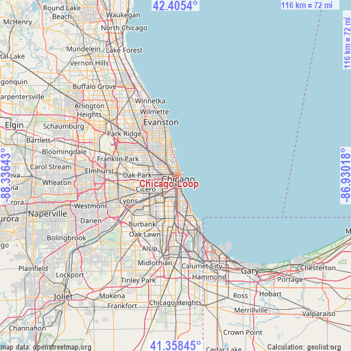
Chicago Loop GPS coordinates[2]
41° 53' 2.652" North, 87° 37' 59.88" West
| Map corner | latitude | longitude |
|---|---|---|
| Upper-left | 42.4054°, | -88.33643° |
| Center: | 41.88407°, | -87.6333° |
| Lower-right: | 41.35845°, | -86.93018° |
| Map W x H: | 116.4×116.4 km | = 72.3×72.3mi |
| max Lat: | 71.29058° ⇑25.4% North |
| Chicago Loop: | 41.88407° |
| min Lat: | ⇓74.6% South 19.06759° |
| min Long | Chicago Loop | max Long |
| -171.73463° | -87.6333° | -66.98998° |
| W 48.9%⇐ | ⇒51.1% E |
Elevation
Elevation of Chicago Loop is 185 m = 607 ft, and this is 109.8 m = 360 ft below average elevation for this country.
| Max E: |
3189 m = 10463 ft | 53.6% |
| Avg. | 294.8 m = 967 ft | |
| Chicago Loop | 185 m = 607 ft | |
Min E: |
-60 m = -197 ft | 46.4% |
See also: United States elevation on elevation.city.
Geographical zone
Chicago Loop is located in North temperate zone (between Tropic of Cancer and the Arctic Circle). Distance of this Northern Tropic circle is 2051.2 km =1274.6 mi to South.| Distance of | km | miles | from Chicago Loop |
|---|---|---|---|
| North Pole | 5350 | 3324.3 | to North |
| Arctic Circle | 2744.1 | 1705.1 | to North |
| Tropic Cancer | 2051.2 | 1274.6 | to South |
| Equator | 4657.1 | 2893.8 | to South |


Nearby cities:
15 places around Chicago Loop: (largest is in red/bold)
• Bridgeport
5.3 km =3.3 mi,  196°
196°
• Chicago
4 km =2.5 mi, 200°
• Douglas
5.6 km =3.5 mi,  167°
167°
• East Garfield Park
5.8 km =3.6 mi,  266°
266°
• Grand Boulevard
7.9 km =4.9 mi, 170°
• Lincoln Park
4.4 km =2.7 mi,  343°
343°
• Logan Square
7 km =4.3 mi,  308°
308°
• Lower West Side
4.3 km =2.7 mi,  218°
218°
• McKinley Park
6.7 km =4.2 mi,  209°
209°
• Near North Side
1.8 km =1.1 mi,  356°
356°
• Near South Side
3.1 km =1.9 mi, 166°
• North Lawndale
7.5 km =4.7 mi,  249°
249°
• South Lawndale
8 km =5 mi,  235°
235°
• West Garfield Park
7.9 km =4.9 mi, 267°
• West Town
3.6 km =2.2 mi,  287°
287°
Sources, notices
• [Note1] Compared only with cities in United States existing in our database
• [Src1] Map data: © OpenStreetMap contributors (CC-BY-SA)
• [Src2] Other city data from geonames.org with taken over terms of usage.
• [Src3] Geographical zone / Annual Mean Temperature by Robert A. Rohde @ Wikipedia
