Elmhurst geodata
Elmhurst (Illinois) is a populated place; located in United States in America/Chicago (GMT-5) time zone. With population of 45,957 people, there are 1043 cities with bigger population in this country. Compared to other cities in United States, 74.8% of cities are located further ↓South; 52.6% of cities are located further →East and 53.5% of cities have lower elevation than Elmhurst. Note1


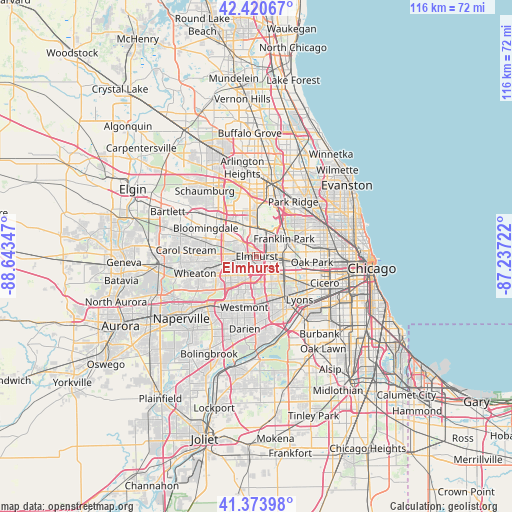
Elmhurst GPS coordinates[2]
41° 53' 58.092" North, 87° 56' 25.224" West
| Map corner | latitude | longitude |
|---|---|---|
| Upper-left | 42.42067°, | -88.64347° |
| Center: | 41.89947°, | -87.94034° |
| Lower-right: | 41.37398°, | -87.23722° |
| Map W x H: | 116.4×116.4 km | = 72.3×72.3mi |
| max Lat: | 71.29058° ⇑25.2% North |
| Elmhurst: | 41.89947° |
| min Lat: | ⇓74.8% South 19.06759° |
| min Long | Elmhurst | max Long |
| -171.73463° | -87.94034° | -66.98998° |
| W 47.4%⇐ | ⇒52.6% E |
Elevation
Elevation of Elmhurst is 212 m = 696 ft, and this is 82.8 m = 272 ft below average elevation for this country.
| Max E: |
3189 m = 10463 ft | 46.5% |
| Avg. | 294.8 m = 967 ft | |
| Elmhurst | 212 m = 696 ft | |
Min E: |
-60 m = -197 ft | 53.5% |
See also: Elmhurst elevation on elevation.city.
Geographical zone
Elmhurst is located in North temperate zone (between Tropic of Cancer and the Arctic Circle). Distance of this Northern Tropic circle is 2052.9 km =1275.6 mi to South.| Distance of | km | miles | from Elmhurst |
|---|---|---|---|
| North Pole | 5348.3 | 3323.3 | to North |
| Arctic Circle | 2742.4 | 1704 | to North |
| Tropic Cancer | 2052.9 | 1275.6 | to South |
| Equator | 4658.8 | 2894.8 | to South |


Nearby cities:
15 places around Elmhurst: (largest is in red/bold)
• Addison
5.4 km =3.4 mi,  311°
311°
• Bellwood
5.1 km =3.2 mi,  112°
112°
• Bensenville
6.2 km =3.9 mi,  0°
0°
• Berkeley
3.3 km =2.1 mi, 110°
• Franklin Park
7.4 km =4.6 mi,  57°
57°
• Hillside
3.9 km =2.4 mi,  127°
127°
• Lombard
6 km =3.7 mi,  248°
248°
• Melrose Park
6.9 km =4.3 mi,  88°
88°
• Northlake
4.2 km =2.6 mi, 61°
• Oak Brook
7.5 km =4.7 mi,  172°
172°
• Oakbrook Terrace
5.9 km =3.7 mi,  200°
200°
• Stone Park
4.7 km =2.9 mi,  81°
81°
• Villa Park
4.2 km =2.6 mi, 254°
• Westchester
7.3 km =4.5 mi,  138°
138°
• Wood Dale
7.8 km =4.8 mi,  335°
335°
Sources, notices
• [Note1] Compared only with cities in United States existing in our database
• [Src1] Map data: © OpenStreetMap contributors (CC-BY-SA)
• [Src2] Other city data from geonames.org with taken over terms of usage.
• [Src3] Geographical zone / Annual Mean Temperature by Robert A. Rohde @ Wikipedia
