Lombard geodata
Lombard (Illinois) is a populated place; located in United States in America/Chicago (GMT-5) time zone. With population of 43,797 people, there are 1091 cities with bigger population in this country. Compared to other cities in United States, 74.6% of cities are located further ↓South; 52.9% of cities are located further →East and 56.4% of cities have lower elevation than Lombard. Note1


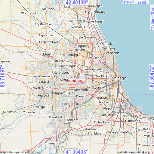
Lombard GPS coordinates[2]
41° 52' 48.108" North, 88° 0' 28.224" West
| Map corner | latitude | longitude |
|---|---|---|
| Upper-left | 42.40139°, | -88.71097° |
| Center: | 41.88003°, | -88.00784° |
| Lower-right: | 41.35438°, | -87.30472° |
| Map W x H: | 116.4×116.4 km | = 72.3×72.3mi |
| max Lat: | 71.29058° ⇑25.4% North |
| Lombard: | 41.88003° |
| min Lat: | ⇓74.6% South 19.06759° |
| min Long | Lombard | max Long |
| -171.73463° | -88.00784° | -66.98998° |
| W 47.1%⇐ | ⇒52.9% E |
Elevation
Elevation of Lombard is 224 m = 735 ft, and this is 70.8 m = 232 ft below average elevation for this country.
| Max E: |
3189 m = 10463 ft | 43.6% |
| Avg. | 294.8 m = 967 ft | |
| Lombard | 224 m = 735 ft | |
Min E: |
-60 m = -197 ft | 56.4% |
See also: Lombard elevation on elevation.city.
Geographical zone
Lombard is located in North temperate zone (between Tropic of Cancer and the Arctic Circle). Distance of this Northern Tropic circle is 2050.7 km =1274.2 mi to South.| Distance of | km | miles | from Lombard |
|---|---|---|---|
| North Pole | 5350.4 | 3324.6 | to North |
| Arctic Circle | 2744.6 | 1705.4 | to North |
| Tropic Cancer | 2050.7 | 1274.2 | to South |
| Equator | 4656.6 | 2893.5 | to South |


Nearby cities:
15 places around Lombard: (largest is in red/bold)
• Addison
6 km =3.7 mi,  15°
15°
• Bensenville
10 km =6.2 mi,  33°
33°
• Berkeley
8.7 km =5.4 mi,  83°
83°
• Downers Grove
7.9 km =4.9 mi,  181°
181°
• Elmhurst
6 km =3.7 mi,  68°
68°
• Glen Ellyn
4.9 km =3 mi,  266°
266°
• Glendale Heights
6.1 km =3.8 mi,  309°
309°
• Hillside
8.7 km =5.4 mi,  91°
91°
• Northlake
10.2 km =6.3 mi, 65°
• Oak Brook
8.4 km =5.2 mi,  128°
128°
• Oakbrook Terrace
4.9 km =3 mi, 132°
• Villa Park
1.9 km =1.2 mi,  55°
55°
• Westmont
9.7 km =6 mi,  164°
164°
• Wheaton
8.4 km =5.2 mi,  259°
259°
• Wood Dale
9.6 km =6 mi,  14°
14°
Sources, notices
• [Note1] Compared only with cities in United States existing in our database
• [Src1] Map data: © OpenStreetMap contributors (CC-BY-SA)
• [Src2] Other city data from geonames.org with taken over terms of usage.
• [Src3] Geographical zone / Annual Mean Temperature by Robert A. Rohde @ Wikipedia
