Elwood geodata
Elwood (Illinois) is a populated place; located in United States in America/Chicago (GMT-5) time zone. With population of 2,258 people, there are 11195 cities with bigger population in this country. Compared to other cities in United States, 69.8% of cities are located further ↓South; 53.4% of cities are located further →East and 50.2% of cities have lower elevation than Elwood. Note1


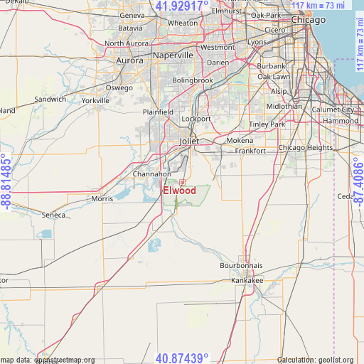
Elwood GPS coordinates[2]
41° 24' 14.112" North, 88° 6' 42.192" West
| Map corner | latitude | longitude |
|---|---|---|
| Upper-left | 41.92917°, | -88.81485° |
| Center: | 41.40392°, | -88.11172° |
| Lower-right: | 40.87439°, | -87.4086° |
| Map W x H: | 117.3×117.3 km | = 72.9×72.9mi |
| max Lat: | 71.29058° ⇑30.2% North |
| Elwood: | 41.40392° |
| min Lat: | ⇓69.8% South 19.06759° |
| min Long | Elwood | max Long |
| -171.73463° | -88.11172° | -66.98998° |
| W 46.6%⇐ | ⇒53.4% E |
Elevation
Elevation of Elwood is 199 m = 653 ft, and this is 95.8 m = 314 ft below average elevation for this country.
| Max E: |
3189 m = 10463 ft | 49.8% |
| Avg. | 294.8 m = 967 ft | |
| Elwood | 199 m = 653 ft | |
Min E: |
-60 m = -197 ft | 50.2% |
See also: United States elevation on elevation.city.
Geographical zone
Elwood is located in North temperate zone (between Tropic of Cancer and the Arctic Circle). Distance of this Northern Tropic circle is 1997.8 km =1241.4 mi to South.| Distance of | km | miles | from Elwood |
|---|---|---|---|
| North Pole | 5403.4 | 3357.5 | to North |
| Arctic Circle | 2797.5 | 1738.3 | to North |
| Tropic Cancer | 1997.8 | 1241.4 | to South |
| Equator | 4603.7 | 2860.6 | to South |


Nearby cities:
15 places around Elwood: (largest is in red/bold)
• Braidwood
17.6 km =10.9 mi,  208°
208°
• Channahon
10.2 km =6.3 mi,  286°
286°
• Crest Hill
16.8 km =10.4 mi,  3°
3°
• Diamond
17.3 km =10.7 mi,  222°
222°
• Fairmont
17.5 km =10.9 mi,  14°
14°
• Ingalls Park
14.4 km =8.9 mi,  23°
23°
• Joliet
13.7 km =8.5 mi, 9°
• Lakewood Shores
13.9 km =8.6 mi,  191°
191°
• Manhattan
10.7 km =6.6 mi,  78°
78°
• Minooka
13.7 km =8.5 mi, 294°
• New Lenox
17.1 km =10.6 mi,  45°
45°
• Preston Heights
10.1 km =6.3 mi, 14°
• Rockdale
11.4 km =7.1 mi,  358°
358°
• Shorewood
14.9 km =9.3 mi,  329°
329°
• Wilmington
11.1 km =6.9 mi,  195°
195°
Sources, notices
• [Note1] Compared only with cities in United States existing in our database
• [Src1] Map data: © OpenStreetMap contributors (CC-BY-SA)
• [Src2] Other city data from geonames.org with taken over terms of usage.
• [Src3] Geographical zone / Annual Mean Temperature by Robert A. Rohde @ Wikipedia
