Joliet geodata
Joliet (Illinois) is a seat of a second-order administrative division; located in United States in America/Chicago (GMT-5) time zone. With population of 147,861 people, there are 201 cities with bigger population in this country. Compared to other cities in United States, 71.1% of cities are located further ↓South; 53.3% of cities are located further →East and 57.7% of cities have higher elevation than Joliet. Note1


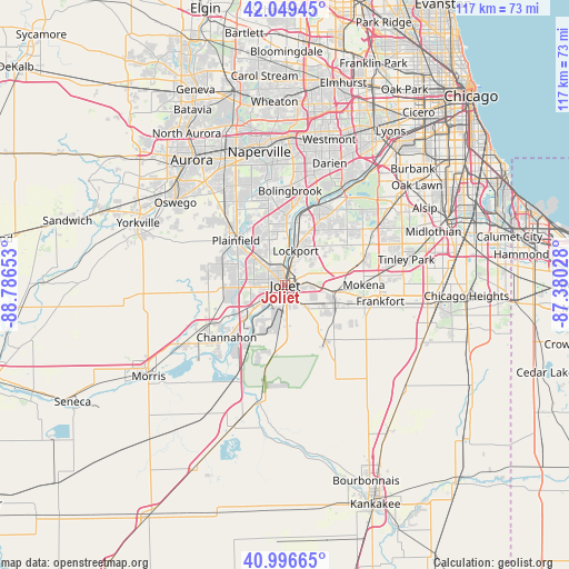
Joliet GPS coordinates[2]
41° 31' 30.684" North, 88° 5' 0.24" West
| Map corner | latitude | longitude |
|---|---|---|
| Upper-left | 42.04945°, | -88.78653° |
| Center: | 41.52519°, | -88.0834° |
| Lower-right: | 40.99665°, | -87.38028° |
| Map W x H: | 117.1×117.1 km | = 72.8×72.8mi |
| max Lat: | 71.29058° ⇑28.9% North |
| Joliet: | 41.52519° |
| min Lat: | ⇓71.1% South 19.06759° |
| min Long | Joliet | max Long |
| -171.73463° | -88.0834° | -66.98998° |
| W 46.7%⇐ | ⇒53.3% E |
Elevation
Elevation of Joliet is 167 m = 548 ft, and this is 127.8 m = 419 ft below average elevation for this country.
| Max E: |
3189 m = 10463 ft | 57.7% |
| Avg. | 294.8 m = 967 ft | |
| Joliet | 167 m = 548 ft | |
Min E: |
-60 m = -197 ft | 42.3% |
See also: Joliet elevation on elevation.city.
Geographical zone
Joliet is located in North temperate zone (between Tropic of Cancer and the Arctic Circle). Distance of this Northern Tropic circle is 2011.2 km =1249.7 mi to South.| Distance of | km | miles | from Joliet |
|---|---|---|---|
| North Pole | 5389.9 | 3349.1 | to North |
| Arctic Circle | 2784 | 1729.9 | to North |
| Tropic Cancer | 2011.2 | 1249.7 | to South |
| Equator | 4617.2 | 2869 | to South |


Nearby cities:
15 places around Joliet: (largest is in red/bold)
• Channahon
16.1 km =10 mi,  228°
228°
• Crest Hill
3.5 km =2.2 mi,  338°
338°
• Crystal Lawns
8 km =5 mi,  308°
308°
• Elwood
13.7 km =8.5 mi,  189°
189°
• Fairmont
4 km =2.5 mi,  30°
30°
• Homer Glen
14.7 km =9.1 mi,  55°
55°
• Ingalls Park
3.4 km =2.1 mi,  95°
95°
• Lockport
7.5 km =4.7 mi,  16°
16°
• Manhattan
14 km =8.7 mi,  144°
144°
• New Lenox
9.9 km =6.2 mi, 98°
• Plainfield
15.1 km =9.4 mi,  318°
318°
• Preston Heights
3.7 km =2.3 mi,  177°
177°
• Rockdale
3.3 km =2.1 mi, 230°
• Romeoville
13.6 km =8.5 mi,  357°
357°
• Shorewood
9.9 km =6.2 mi,  266°
266°
Sources, notices
• [Note1] Compared only with cities in United States existing in our database
• [Src1] Map data: © OpenStreetMap contributors (CC-BY-SA)
• [Src2] Other city data from geonames.org with taken over terms of usage.
• [Src3] Geographical zone / Annual Mean Temperature by Robert A. Rohde @ Wikipedia
