Eureka geodata
Eureka (Illinois) is a seat of a second-order administrative division; located in United States in America/Chicago (GMT-5) time zone. With population of 5,377 people, there are 6858 cities with bigger population in this country. Compared to other cities in United States, 61.9% of cities are located further ↓South; 56.9% of cities are located further →East and 59.4% of cities have lower elevation than Eureka. Note1


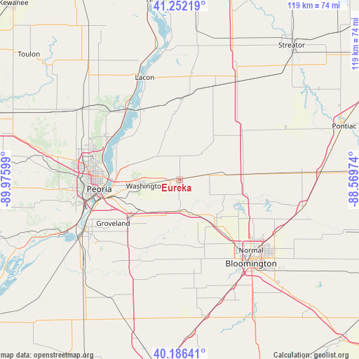
Eureka GPS coordinates[2]
40° 43' 17.148" North, 89° 16' 22.296" West
| Map corner | latitude | longitude |
|---|---|---|
| Upper-left | 41.25219°, | -89.97599° |
| Center: | 40.72143°, | -89.27286° |
| Lower-right: | 40.18641°, | -88.56974° |
| Map W x H: | 118.5×118.5 km | = 73.6×73.6mi |
| max Lat: | 71.29058° ⇑38.1% North |
| Eureka: | 40.72143° |
| min Lat: | ⇓61.9% South 19.06759° |
| min Long | Eureka | max Long |
| -171.73463° | -89.27286° | -66.98998° |
| W 43.1%⇐ | ⇒56.9% E |
Elevation
Elevation of Eureka is 237 m = 778 ft, and this is 57.8 m = 190 ft below average elevation for this country.
| Max E: |
3189 m = 10463 ft | 40.6% |
| Avg. | 294.8 m = 967 ft | |
| Eureka | 237 m = 778 ft | |
Min E: |
-60 m = -197 ft | 59.4% |
See also: United States elevation on elevation.city.
Geographical zone
Eureka is located in North temperate zone (between Tropic of Cancer and the Arctic Circle). Distance of this Northern Tropic circle is 1921.9 km =1194.2 mi to South.| Distance of | km | miles | from Eureka |
|---|---|---|---|
| North Pole | 5479.3 | 3404.7 | to North |
| Arctic Circle | 2873.4 | 1785.4 | to North |
| Tropic Cancer | 1921.9 | 1194.2 | to South |
| Equator | 4527.8 | 2813.4 | to South |


Nearby cities:
15 places around Eureka: (largest is in red/bold)
• Carlock
19.5 km =12.1 mi,  142°
142°
• Danvers
22.8 km =14.2 mi,  159°
159°
• Deer Creek
11.3 km =7 mi,  206°
206°
• El Paso
21.7 km =13.5 mi,  84°
84°
• Germantown Hills
17.2 km =10.7 mi,  286°
286°
• Goodfield
10.2 km =6.3 mi,  180°
180°
• Heritage Lake
19.9 km =12.4 mi,  193°
193°
• Mackinaw
21.7 km =13.5 mi,  199°
199°
• Metamora
10.7 km =6.6 mi,  316°
316°
• Morton
19.8 km =12.3 mi,  232°
232°
• North Peoria
26.2 km =16.3 mi,  269°
269°
• Peoria Heights
25.5 km =15.8 mi,  276°
276°
• Roanoke
10.5 km =6.5 mi,  37°
37°
• Washburn
22 km =13.7 mi,  355°
355°
• Washington
11.5 km =7.1 mi,  260°
260°
Sources, notices
• [Note1] Compared only with cities in United States existing in our database
• [Src1] Map data: © OpenStreetMap contributors (CC-BY-SA)
• [Src2] Other city data from geonames.org with taken over terms of usage.
• [Src3] Geographical zone / Annual Mean Temperature by Robert A. Rohde @ Wikipedia
