El Paso geodata
El Paso (Illinois) is a populated place; located in United States in America/Chicago (GMT-5) time zone. With population of 2,798 people, there are 9995 cities with bigger population in this country. Compared to other cities in United States, 62.2% of cities are located further ↓South; 56.1% of cities are located further →East and 57.9% of cities have lower elevation than El Paso. Note1


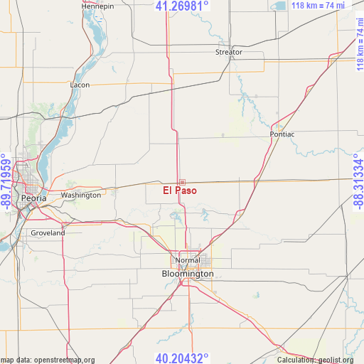
El Paso GPS coordinates[2]
40° 44' 21.12" North, 89° 0' 59.256" West
| Map corner | latitude | longitude |
|---|---|---|
| Upper-left | 41.26981°, | -89.71959° |
| Center: | 40.7392°, | -89.01646° |
| Lower-right: | 40.20432°, | -88.31334° |
| Map W x H: | 118.5×118.5 km | = 73.6×73.6mi |
| max Lat: | 71.29058° ⇑37.8% North |
| El Paso: | 40.7392° |
| min Lat: | ⇓62.2% South 19.06759° |
| min Long | El Paso | max Long |
| -171.73463° | -89.01646° | -66.98998° |
| W 43.9%⇐ | ⇒56.1% E |
Elevation
Elevation of El Paso is 230 m = 755 ft, and this is 64.8 m = 213 ft below average elevation for this country.
| Max E: |
3189 m = 10463 ft | 42.1% |
| Avg. | 294.8 m = 967 ft | |
| El Paso | 230 m = 755 ft | |
Min E: |
-60 m = -197 ft | 57.9% |
See also: United States elevation on elevation.city.
Geographical zone
El Paso is located in North temperate zone (between Tropic of Cancer and the Arctic Circle). Distance of this Northern Tropic circle is 1923.9 km =1195.5 mi to South.| Distance of | km | miles | from El Paso |
|---|---|---|---|
| North Pole | 5477.3 | 3403.4 | to North |
| Arctic Circle | 2871.4 | 1784.2 | to North |
| Tropic Cancer | 1923.9 | 1195.5 | to South |
| Equator | 4529.8 | 2814.7 | to South |


Nearby cities:
15 places around El Paso: (largest is in red/bold)
• Bloomington
28.4 km =17.6 mi,  176°
176°
• Carlock
20 km =12.4 mi,  209°
209°
• Chenoa
25 km =15.5 mi,  89°
89°
• Danvers
27 km =16.8 mi, 210°
• Eureka
21.7 km =13.5 mi,  264°
264°
• Flanagan
20.2 km =12.6 mi,  40°
40°
• Goodfield
25 km =15.5 mi,  240°
240°
• Gridley
11.4 km =7.1 mi, 87°
• Hudson
15 km =9.3 mi,  170°
170°
• Lexington
22.5 km =14 mi,  118°
118°
• Minonk
18.4 km =11.4 mi,  355°
355°
• Normal
25.1 km =15.6 mi, 175°
• Pleasant Hill
26.7 km =16.6 mi, 121°
• Roanoke
16.5 km =10.3 mi,  292°
292°
• Twin Grove
27.9 km =17.3 mi,  191°
191°
Sources, notices
• [Note1] Compared only with cities in United States existing in our database
• [Src1] Map data: © OpenStreetMap contributors (CC-BY-SA)
• [Src2] Other city data from geonames.org with taken over terms of usage.
• [Src3] Geographical zone / Annual Mean Temperature by Robert A. Rohde @ Wikipedia
