Glenview geodata
Glenview (Illinois) is a populated place; located in United States in America/Chicago (GMT-5) time zone. With population of 47,446 people, there are 1015 cities with bigger population in this country. Compared to other cities in United States, 76.3% of cities are located further ↓South; 51.9% of cities are located further →East and 51.5% of cities have lower elevation than Glenview. Note1


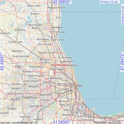
Glenview GPS coordinates[2]
42° 4' 11.1" North, 87° 47' 16.224" West
| Map corner | latitude | longitude |
|---|---|---|
| Upper-left | 42.58955°, | -88.49097° |
| Center: | 42.06975°, | -87.78784° |
| Lower-right: | 41.54565°, | -87.08472° |
| Map W x H: | 116.1×116.1 km | = 72.1×72.1mi |
| max Lat: | 71.29058° ⇑23.7% North |
| Glenview: | 42.06975° |
| min Lat: | ⇓76.3% South 19.06759° |
| min Long | Glenview | max Long |
| -171.73463° | -87.78784° | -66.98998° |
| W 48.1%⇐ | ⇒51.9% E |
Elevation
Elevation of Glenview is 204 m = 669 ft, and this is 90.8 m = 298 ft below average elevation for this country.
| Max E: |
3189 m = 10463 ft | 48.5% |
| Avg. | 294.8 m = 967 ft | |
| Glenview | 204 m = 669 ft | |
Min E: |
-60 m = -197 ft | 51.5% |
See also: Glenview elevation on elevation.city.
Geographical zone
Glenview is located in North temperate zone (between Tropic of Cancer and the Arctic Circle). Distance of this Northern Tropic circle is 2071.8 km =1287.4 mi to South.| Distance of | km | miles | from Glenview |
|---|---|---|---|
| North Pole | 5329.3 | 3311.5 | to North |
| Arctic Circle | 2723.5 | 1692.3 | to North |
| Tropic Cancer | 2071.8 | 1287.4 | to South |
| Equator | 4677.7 | 2906.6 | to South |


Nearby cities:
15 places around Glenview: (largest is in red/bold)
• Des Plaines
8.9 km =5.5 mi,  242°
242°
• Evanston
8.7 km =5.4 mi,  111°
111°
• Glencoe
7.7 km =4.8 mi,  18°
18°
• Golf
1.3 km =0.8 mi,  197°
197°
• Kenilworth
6.1 km =3.8 mi,  72°
72°
• Lincolnwood
8.7 km =5.4 mi,  146°
146°
• Morton Grove
3.3 km =2.1 mi,  172°
172°
• Niles
5.8 km =3.6 mi,  192°
192°
• Northbrook
7.3 km =4.5 mi,  332°
332°
• Northfield
3.4 km =2.1 mi,  9°
9°
• Park Ridge
7.8 km =4.8 mi,  213°
213°
• Skokie
6 km =3.7 mi,  131°
131°
• West Ridge
11.1 km =6.9 mi, 134°
• Wilmette
5.4 km =3.4 mi,  87°
87°
• Winnetka
6 km =3.7 mi,  45°
45°
Sources, notices
• [Note1] Compared only with cities in United States existing in our database
• [Src1] Map data: © OpenStreetMap contributors (CC-BY-SA)
• [Src2] Other city data from geonames.org with taken over terms of usage.
• [Src3] Geographical zone / Annual Mean Temperature by Robert A. Rohde @ Wikipedia
