Evanston geodata
Evanston (Illinois) is a populated place; located in United States in America/Chicago (GMT-5) time zone. With population of 75,527 people, there are 534 cities with bigger population in this country. Compared to other cities in United States, 76% of cities are located further ↓South; 51.4% of cities are located further →East and 52.5% of cities have higher elevation than Evanston. Note1


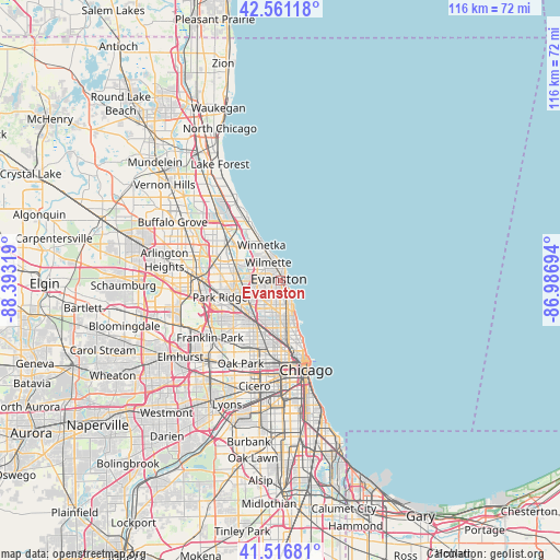
Evanston GPS coordinates[2]
42° 2' 28.104" North, 87° 41' 24.216" West
| Map corner | latitude | longitude |
|---|---|---|
| Upper-left | 42.56118°, | -88.39319° |
| Center: | 42.04114°, | -87.69006° |
| Lower-right: | 41.51681°, | -86.98694° |
| Map W x H: | 116.1×116.1 km | = 72.1×72.1mi |
| max Lat: | 71.29058° ⇑24% North |
| Evanston: | 42.04114° |
| min Lat: | ⇓76% South 19.06759° |
| min Long | Evanston | max Long |
| -171.73463° | -87.69006° | -66.98998° |
| W 48.6%⇐ | ⇒51.4% E |
Elevation
Elevation of Evanston is 189 m = 620 ft, and this is 105.8 m = 347 ft below average elevation for this country.
| Max E: |
3189 m = 10463 ft | 52.5% |
| Avg. | 294.8 m = 967 ft | |
| Evanston | 189 m = 620 ft | |
Min E: |
-60 m = -197 ft | 47.5% |
See also: Evanston elevation on elevation.city.
Geographical zone
Evanston is located in North temperate zone (between Tropic of Cancer and the Arctic Circle). Distance of this Northern Tropic circle is 2068.6 km =1285.4 mi to South.| Distance of | km | miles | from Evanston |
|---|---|---|---|
| North Pole | 5332.5 | 3313.5 | to North |
| Arctic Circle | 2726.6 | 1694.2 | to North |
| Tropic Cancer | 2068.6 | 1285.4 | to South |
| Equator | 4674.5 | 2904.6 | to South |


Nearby cities:
15 places around Evanston: (largest is in red/bold)
• Albany Park
8.5 km =5.3 mi,  198°
198°
• Edgewater
6.8 km =4.2 mi,  161°
161°
• Glenview
8.7 km =5.4 mi,  291°
291°
• Golf
8.7 km =5.4 mi,  283°
283°
• Kenilworth
5.5 km =3.4 mi,  335°
335°
• Lincoln Square
7.3 km =4.5 mi,  179°
179°
• Lincolnwood
5.2 km =3.2 mi,  219°
219°
• Morton Grove
7.6 km =4.7 mi,  269°
269°
• Niles
9.6 km =6 mi,  255°
255°
• Rogers Park
4.1 km =2.5 mi,  151°
151°
• Skokie
3.7 km =2.3 mi, 256°
• Uptown
8.9 km =5.5 mi, 159°
• West Ridge
4.6 km =2.9 mi, 182°
• Wilmette
4.4 km =2.7 mi,  321°
321°
• Winnetka
8.3 km =5.2 mi,  333°
333°
Sources, notices
• [Note1] Compared only with cities in United States existing in our database
• [Src1] Map data: © OpenStreetMap contributors (CC-BY-SA)
• [Src2] Other city data from geonames.org with taken over terms of usage.
• [Src3] Geographical zone / Annual Mean Temperature by Robert A. Rohde @ Wikipedia
