Harwood Heights geodata
Harwood Heights (Illinois) is a populated place; located in United States in America/Chicago (GMT-5) time zone. With population of 8,635 people, there are 4957 cities with bigger population in this country. Compared to other cities in United States, 75.4% of cities are located further ↓South; 51.9% of cities are located further →East and 50.5% of cities have lower elevation than Harwood Heights. Note1
Administrative division(s):
- Level 1: Illinois
- Level 2: Cook County
- Level 3: Township of Norwood Park


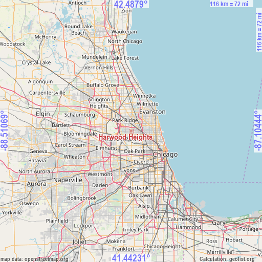
Harwood Heights GPS coordinates[2]
41° 58' 2.1" North, 87° 48' 27.216" West
| Map corner | latitude | longitude |
|---|---|---|
| Upper-left | 42.4879°, | -88.51069° |
| Center: | 41.96725°, | -87.80756° |
| Lower-right: | 41.44231°, | -87.10444° |
| Map W x H: | 116.3×116.3 km | = 72.3×72.3mi |
| max Lat: | 71.29058° ⇑24.6% North |
| Harwood Heights: | 41.96725° |
| min Lat: | ⇓75.4% South 19.06759° |
| min Long | Harwood Heights | max Long |
| -171.73463° | -87.80756° | -66.98998° |
| W 48.1%⇐ | ⇒51.9% E |
Elevation
Elevation of Harwood Heights is 200 m = 656 ft, and this is 94.8 m = 311 ft below average elevation for this country.
| Max E: |
3189 m = 10463 ft | 49.5% |
| Avg. | 294.8 m = 967 ft | |
| Harwood Heights | 200 m = 656 ft | |
Min E: |
-60 m = -197 ft | 50.5% |
See also: United States elevation on elevation.city.
Geographical zone
Harwood Heights is located in North temperate zone (between Tropic of Cancer and the Arctic Circle). Distance of this Northern Tropic circle is 2060.4 km =1280.3 mi to South.| Distance of | km | miles | from Harwood Heights |
|---|---|---|---|
| North Pole | 5340.7 | 3318.6 | to North |
| Arctic Circle | 2734.9 | 1699.4 | to North |
| Tropic Cancer | 2060.4 | 1280.3 | to South |
| Equator | 4666.3 | 2899.5 | to South |


Nearby cities:
15 places around Harwood Heights: (largest is in red/bold)
• Albany Park
7 km =4.3 mi,  88°
88°
• Belmont Cragin
5.1 km =3.2 mi,  140°
140°
• Elmwood Park
5.1 km =3.2 mi,  181°
181°
• Franklin Park
6 km =3.7 mi,  233°
233°
• Irving Park
6.1 km =3.8 mi,  104°
104°
• Lincolnwood
7.6 km =4.7 mi,  57°
57°
• Morton Grove
8.4 km =5.2 mi,  14°
14°
• Niles
5.8 km =3.6 mi,  3°
3°
• Norridge
1.7 km =1.1 mi,  255°
255°
• Park Ridge
5.6 km =3.5 mi,  330°
330°
• Portage Park
3.7 km =2.3 mi,  106°
106°
• River Forest
7.7 km =4.8 mi, 183°
• River Grove
5.2 km =3.2 mi,  206°
206°
• Rosemont
7.1 km =4.4 mi,  296°
296°
• Schiller Park
5.4 km =3.4 mi, 256°
Sources, notices
• [Note1] Compared only with cities in United States existing in our database
• [Src1] Map data: © OpenStreetMap contributors (CC-BY-SA)
• [Src2] Other city data from geonames.org with taken over terms of usage.
• [Src3] Geographical zone / Annual Mean Temperature by Robert A. Rohde @ Wikipedia
