Mokena geodata
Mokena (Illinois) is a populated place; located in United States in America/Chicago (GMT-5) time zone. With population of 19,923 people, there are 2528 cities with bigger population in this country. Compared to other cities in United States, 71.1% of cities are located further ↓South; 52.3% of cities are located further →East and 54.7% of cities have lower elevation than Mokena. Note1


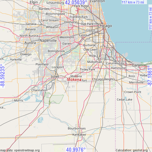
Mokena GPS coordinates[2]
41° 31' 34.104" North, 87° 53' 21.192" West
| Map corner | latitude | longitude |
|---|---|---|
| Upper-left | 42.05039°, | -88.59235° |
| Center: | 41.52614°, | -87.88922° |
| Lower-right: | 40.9976°, | -87.1861° |
| Map W x H: | 117.1×117.1 km | = 72.8×72.8mi |
| max Lat: | 71.29058° ⇑28.9% North |
| Mokena: | 41.52614° |
| min Lat: | ⇓71.1% South 19.06759° |
| min Long | Mokena | max Long |
| -171.73463° | -87.88922° | -66.98998° |
| W 47.7%⇐ | ⇒52.3% E |
Elevation
Elevation of Mokena is 217 m = 712 ft, and this is 77.8 m = 255 ft below average elevation for this country.
| Max E: |
3189 m = 10463 ft | 45.3% |
| Avg. | 294.8 m = 967 ft | |
| Mokena | 217 m = 712 ft | |
Min E: |
-60 m = -197 ft | 54.7% |
See also: United States elevation on elevation.city.
Geographical zone
Mokena is located in North temperate zone (between Tropic of Cancer and the Arctic Circle). Distance of this Northern Tropic circle is 2011.4 km =1249.8 mi to South.| Distance of | km | miles | from Mokena |
|---|---|---|---|
| North Pole | 5389.8 | 3349.1 | to North |
| Arctic Circle | 2783.9 | 1729.8 | to North |
| Tropic Cancer | 2011.4 | 1249.8 | to South |
| Equator | 4617.3 | 2869.1 | to South |


Nearby cities:
15 places around Mokena: (largest is in red/bold)
• Country Club Hills
14.8 km =9.2 mi,  71°
71°
• Fairmont
14.5 km =9 mi,  283°
283°
• Frankfort
4.8 km =3 mi,  134°
134°
• Frankfort Square
7.2 km =4.5 mi,  96°
96°
• Goodings Grove
12 km =7.5 mi,  343°
343°
• Homer Glen
9.2 km =5.7 mi,  333°
333°
• Ingalls Park
12.8 km =8 mi,  268°
268°
• Lockport
15.7 km =9.8 mi,  296°
296°
• Manhattan
14.1 km =8.8 mi,  214°
214°
• Matteson
14.9 km =9.3 mi, 99°
• New Lenox
6.6 km =4.1 mi,  256°
256°
• Oak Forest
14.8 km =9.2 mi,  54°
54°
• Orland Hills
7.6 km =4.7 mi,  30°
30°
• Orland Park
11.9 km =7.4 mi,  14°
14°
• Tinley Park
10.2 km =6.3 mi,  58°
58°
Sources, notices
• [Note1] Compared only with cities in United States existing in our database
• [Src1] Map data: © OpenStreetMap contributors (CC-BY-SA)
• [Src2] Other city data from geonames.org with taken over terms of usage.
• [Src3] Geographical zone / Annual Mean Temperature by Robert A. Rohde @ Wikipedia
